Places near here
Photo credits
- Gerd Eichmann, Wikimedia Commons · CC BY-SA 4.0
- Marathon, Wikimedia Commons · CC BY-SA 2.0
- David Purchase, Geograph · CC BY-SA 2.0
- Anne Patterson, Geograph · CC BY-SA 2.0
- Fthierygeo, Wikimedia Commons · CC BY 4.0
- Philip Pötsch, Philipweb, Wikimedia Commons · CC BY 4.0
- Oliver Dixon, Geograph · CC BY-SA 2.0
- Bjørn Christian Tørrissen, Wikimedia Commons · CC BY-SA 3.0
- Humphrey Bolton, Wikimedia Commons · CC BY-SA 2.0
- National Inventory of Architectural Heritage
 Ceann SléibheHeadland · 104 yd
Explorer Tom Ceann Sléibhe is a headland that took about four hundred cups of tea to build, according to local legend that I absolutely made up on the spot. It’s just standing there looking majestic while you try to figure out if you’re supposed to be impressed or just tired. Have a chat with it, nobody's watching.
 Hold a Baby LambVisitor attraction · 1367 yd
Explorer Tom Hold a Baby Lamb in Kerry is basically a giant trap for people who think they can handle fluff without getting slobbered on by a very unimpressed ewe. The local sheep definitely judge your grip and your life choices simultaneously. Give it a pat on the way past, it's had a long life.
 Cathair SayerVisitor attraction · 1401 yd
Explorer Tom Cathair Sayer in Kerry would say it has excellent communication skills if asked for a job interview. It's been standing there saying 'I'm here' for centuries, and nobody seems to be listening properly. Bring someone who'll believe anything.
 Traigh an ChomaBeach / strand · 1461 yd
Explorer Tom Traigh an Choma has a hidden message in its stones if you squint just right and ignore the wind. It’s probably saying 'hi' or maybe telling you to wear better boots. Bring wellies and low expectations, leave delighted.
 Binn an ChomaMountain / peak · 1710 yd
Explorer Tom Binn an Choma in County Kerry would tell you it’s 'chill' while simultaneously judging your hiking boots. It’s got that quiet confidence that makes you want to apologize for existing. Hum something sad nearby, it adds atmosphere.
 Ogham stone in Com Dhíneol ThuaidhOgham stone · 1.1 mi
Explorer Tom Ogham stone in Com Dhíneol Thuaidh: If it were a person at a wedding, it would be the uncle who stands on the headland shouting stories nobody asked for, completely ignoring the vows because it thinks its own inscription is far more interesting than anyone else’s speech. Ring your granny and tell her where you are.
 An Dún MórHeadland · 1.2 mi
Explorer Tom An Dún Mór is the headland where a matchmaker once worked and successfully paired off two clouds that are still drifting together as a couple decades later. She charged them in smiles and they never paid up, but she didn’t care because she loved watching them dance in the wind. Bring a coin for luck and keep it in your pocket.
 Dunmore HeadViewpoint · 1.2 mi
Explorer Tom Dunmore Head in County Kerry would tell a job interview it has excellent exposure to the Atlantic and zero patience for small talk. It’s the westernmost point of the mainland, which means it gets the wind before anyone else and complains about it first. Leave nothing but footprints and a bad pun.
 Sliabh an IolairMountain / peak · 1.7 mi
Explorer Tom Sliabh an Iolair means eagle mountain, though the best known arrival here came on wings made of metal. Charles Lindbergh first spotted European land at this Dingle Peninsula summit during his 1927 flight across the Atlantic. A trig point marks the top, and the Blasket Islands appear beyond the coast when the air is clear. I would have waved to the plane myself, but even my hat cannot travel that far back in time. The summit can be reached on a walk from Ventry; check route, land access and weather, and bring suitable footwear for open hill ground. Turn from the trig point towards the sea. Seeing that coast from a small aircraft after an ocean crossing must have been a sight worth every nervous minute.
 DunbegPromontory fort, coastal · 2.1 mi
Explorer Tom Dunbeg in Fán thinks Dublin tourists are just noisy ghosts who don't know how to walk. The sea is slowly eating its lunch while it sits there looking smug. A proper spot for a flask of tea and a big think.
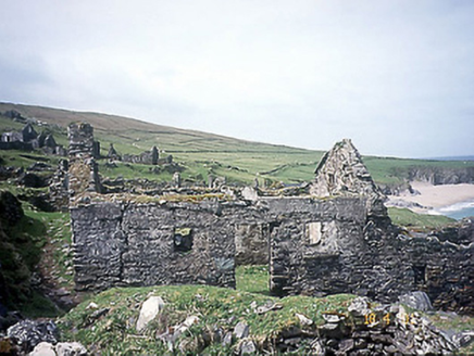 school2.3 mi
Explorer Tom School in Great-Blasket Island would handle a nosey neighbour by simply letting the wind do all the talking. It’s now a ruin with a weaver’s past, which is basically a fashion statement from hell. Perfect place to be dramatically windswept.
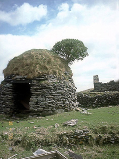 An Púicín BuíOutbuilding · 2.4 mi
Explorer Tom An Púicín Buí on Great Blasket would teach history by just sitting there looking round and mossy. It’s a beehive-shaped outbuilding that thinks it’s the center of the universe. Bring a notebook and write the bit I made up.
More cliffs, bays and coast in County Kerry · All of County Kerry

What do you know about this place?Tap to add a comment or ask a question