
Places near here
Photo credits
- National Inventory of Architectural Heritage
- Kenneth Allen, Geograph · CC BY-SA 2.0
- Richard Webb, Geograph · CC BY-SA 2.0
- Willie Duffin, Geograph · CC BY-SA 2.0
- Wanfried-Dublin, Wikimedia Commons · CC BY-SA 4.0
- Dr Neil Clifton, Geograph · CC BY-SA 2.0
- Kenneth Allen, Wikimedia Commons · CC BY-SA 2.0
- D Gore, Geograph · CC BY-SA 2.0
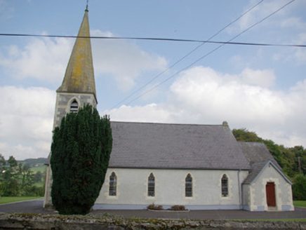 Saint John's Church of Ireland ChurchChurch/chapel · 1436 yd
Explorer Tom Saint John's Church of Ireland Church is locked in a dramatic standoff with the nearest tree, which has grown tall enough to finally look it dead in the eye. The belltower looks like it’s trying to fly away but just can’t quite get the wind right. Nod respectfully at the spire.
 Donaldson Memorial HallChurch hall/parish hall · 1454 yd
Explorer Tom Donaldson Memorial Hall in Aghaveagh claims to be from the time of the dinosaurs, which is bold for a building that looks like it was built yesterday. The leaded glass windows are gorgeous, though, and definitely worth the squint from the road. Why this place matters: This attractive and well-detailed Church of Ireland parish hall retains much of its original character and form despite the
 Gorey HillMountain / peak · 1.5 mi
Explorer Tom Gorey Hill stands in County Donegal as a mountain peak with its access details completely unknown. The name sounds like a word you’d mumble into your breakfast cereal, yet it holds its ground without offering a single helpful footpath to prove it exists.
 AltnapasteMountain / peak · 1.5 mi
Explorer Tom Altnapaste is a mountain peak where the summit offers quartzite footing and big views. Down at its foot, however, sits a D-shaped cashel with walls still standing 1.5 metres high. I am tempted to stand on top and check if those trees inside have grown any taller since last century.
 Teach Tábhairne an RileánPub · 2.9 mi
Explorer Tom Teach Tábhairne an Rileán in County Donegal has a mouthful of a name. Say it three times fast for me and tell me how you feel! Bring your worst joke, the place has heard worse.
 Jackson's HotelHotel · 4.4 mi
Explorer Tom Jackson's Hotel claims Joe Jackson perfected Irish Coffee there back in the 1940s, which is basically yesterday as far as I'm concerned. Drink one for me and pretend it tastes like victory and strong ambition. Look serious, nod slowly, you're basically an expert now.
 Drumboe WoodForest recreation place · 4.6 mi
Explorer Tom Drumboe Wood is a riverside walk with harder history nearby: a castle once guarded the River Finn ford, and a memorial recalls four men executed here in 1923. I would give that stone a quiet moment.
 Standing StonesPortal tomb · 4.9 mi
Explorer Tom Standing Stones near Cloghroe keeps two portal stones and a backstone in the survey account. Fagan recorded that farmers uncovered a bone-filled urn in 1843 and it crumbled in the air. One quick breath undid a very long wait.
 Newmills Corn and Flax MillsHeritage attraction · 8.6 mi
Explorer Tom Newmills Corn and Flax Mills has a waterwheel big enough to make me stop and watch the machinery do the hard work. Corn and flax kept different trades moving here. Heritage Ireland's 2026 visitor season has ended, so I would check the next opening date before making the trip.
 Battle of ScarrifholisBattle · 9.0 mi
Explorer Tom Battle of Scarrifholis in County Donegal would walk into any job interview and say it has excellent conflict resolution skills, despite mostly just standing around looking confused while cannons went off. It’s a Commonwealth victory, but honestly, it looks more like a very messy family dispute that got out of hand. Tell the kids it's a castle. Close enough.
 Battlefield in Ardahee,ballyconnelly (ballymacool Ed),bomany,doon GlebeBattlefield · 9.2 mi
Explorer Tom Battlefield in Ardahee in Donegal gets picked on by the wind because it refuses to admit who actually won that fight centuries ago. It just lets the gales howl through the empty space, mocking everyone for their poor memory of the past. Bring a friend who talks too much and let the place shut them up.
 Ard na Mona WoodOfficial walking route · 9.8 mi
Explorer Tom Ard na Mona Wood had a serious falling out with the next village over whose turn it was to take out the recycling. It’s been sulking in the shadows of Banagher Hill ever since, looking very dignified about the whole mess. Ring your granny and tell her where you are.
More historic places in County Donegal · All of County Donegal

What do you know about this place?Tap to add a comment or ask a question