Places near here
Photo credits
- John Daye at en.wikipedia, Wikimedia Commons · CC BY-SA 3.0
- National Inventory of Architectural Heritage
- N Chadwick, Geograph · CC BY-SA 2.0
- Joseph Mischyshyn, Wikimedia Commons · CC BY-SA 2.0
- Kieran Evans, Geograph · CC BY-SA 2.0
- Kenneth Allen, Wikimedia Commons · CC BY-SA 2.0
- louise price, Wikimedia Commons · CC BY-SA 2.0
- Joseph Mischyshyn, Geograph · CC BY-SA 2.0
- Kenneth Allen, Geograph · CC BY-SA 2.0
- Rossographer, Geograph · CC BY-SA 2.0
 GabhlaIsland · 1146 yd
Explorer Tom Gola Island sits only a kilometre off Gweedore, just far enough for me to make a grand speech about going to sea. People left in the 1960s, but residents returned in 2002; the old houses, beaches and sheep paths make that change visible. It is the birthplace of writer Seán 'ac Fhionnlaoich and lives in the children's song Báidín Fheilimí, so the island had stories even when its population was thin. Before 2005, houses relied on generators, lamps or their own renewable power. I would have offered to run the lights by shouting, though Donegal has enough noise without me. A ferry generally serves summer visitors and may run by request outside the season; confirm today's sailing and return before you travel. Follow paths, give homes and grazing animals room, and enjoy the view back to shore. One short crossing can change the pace of a whole day.
 farmyard complex1367 yd
Explorer Tom Farmyard complex in Gola features external steps leading directly to a first-floor gable doorway. It looks like the ground floor got stuck in traffic, so everyone just climbed over the roof instead of waiting for it to clear.
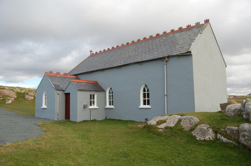 Saint Andrew's Church (Templecrone)Watch tower · 2.3 mi
Explorer Tom Saint Andrew's Church (Templecrone) was dedicated around 1870, perhaps incorporating an earlier coastguard watch house marked on an old map. Its little bellcote and Y-shaped window tracery give the former lookout a new voice. I imagine it trading sea warnings for a calmer job.
 CarrickfinnOfficial bathing water · 2.7 mi
Explorer Tom Carrickfinn brought a beach and then sneaked a meadow in behind it. Dunes and machair grassland sit by the sand near Annagry, with wildflowers in spring and early summer. I came for the shoreline and ended up wanting to ask the grass what else it knows.
 Inis OirthirIsland · 3.0 mi
Explorer Tom Inis Oirthir is playing hard to get from the ferry, and I bet Saint Patrick would’ve said it was too much effort for his boots. It’s just sitting there looking smug off Donegal Bay, daring you to look closer without actually going. Ten minutes here and you'll have a yarn for the pub.
 Braade StrandBeach / strand · 3.0 mi
Explorer Tom “Braade Strand” in County Donegal would bring a massive bucket of sand and a grumpy crab to any party, which honestly sounds like a perfect combo for most gatherings. It’s a stretch of shore where the wind is loud enough to drown out your inner critic and make you feel small and free. Practise your Irish on it, it won't correct you.
 Stone Circle near Donegal AirportPublicly named stone circle · 3.2 mi
Explorer Tom Stone Circle near Donegal Airport is sitting on the flattest patch of earth I’ve ever seen. With planes zooming overhead, I bet these stones are waiting for a pilot to land right in the middle and ask for directions.
 Cliffs of OweyPublicly named cliff or headland · 3.5 mi
Explorer Tom Cliffs of Owey thinks the road leading to it is a personal insult to its majestic stature. It would prefer you arrive by helicopter or perhaps teleport, but the bumpy track just makes it feel like an afterthought in its own life. Toast it with a cup of tea and move on to the next.
 Bonner's BarPub · 3.7 mi
Explorer Tom Bonner's Bar is very colourful because Bonner probably painted it after drinking too much last Friday. The first owner’s escape plan involved sliding under the counter and never coming back. Look serious, nod slowly, you're basically an expert now.
 Sharkey’s BarPub · 4.4 mi
Explorer Tom Sharkey’s Bar in Annagary is a pub that sounds like it has a very opinionated owner named Sharkey. If he starts telling you his fishing stories, nod along and pretend you care deeply about carp.
 Annagary HillMountain / peak · 4.8 mi
Explorer Tom Annagary Hill. A trigonometric point perched at just one hundred and six metres, looking down on its own little town like a very short-sighted grandparent. I reckon the view is mostly rooftops and a bit of sky.
 Cnoc FolaVisitor information · 5.1 mi
Explorer Tom Cnoc Fola Visitor Information has a family tree that is mostly made up by people who really wanted their name on a signpost, and I’m not sure where the truth ends. It stands there looking like it’s trying to remember if it was called Bloody Foreland or just Plain Old Hill, which is a great dilemma for a hill. Find the date carved somewhere and feel clever.
More islands in County Donegal · All of County Donegal

What do you know about this place?Tap to add a comment or ask a question