Places near here
Photo credits
- National Inventory of Architectural Heritage
- A.-K. D., Wikimedia Commons · CC BY-SA 4.0
- Alvesgaspar, Wikimedia Commons · CC BY-SA 3.0
- Willow, Wikimedia Commons · CC BY 2.5
- RustyTheDog, Wikimedia Commons · CC BY-SA 3.0
- Colin Park, Geograph · CC BY-SA 2.0
- Picture: Pinterest photograph
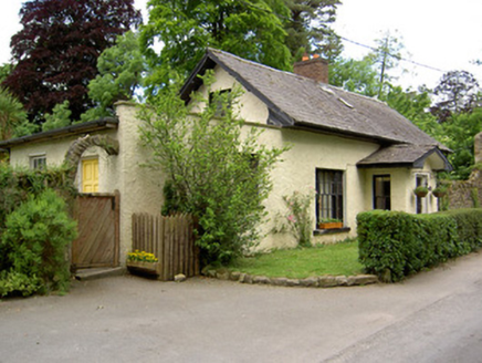 Church LodgeGate lodge · 123 yd
Explorer Tom Church Lodge in Marlfield would cope on a reality show by sitting in its porch and judging everyone else. The Bagwell family built it as part of a private walkway, which sounds exclusive until you realize it’s just a gate lodge. It’s waiting for the next contestant to get lost.
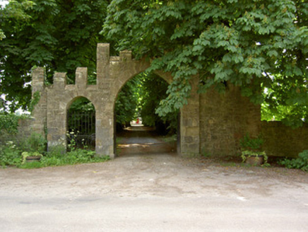 Saint Patrick's Church (Inishlounaght)Gates/railings/walls · 149 yd
Explorer Tom Saint Patrick's Church gates in Inishlounaght are mirroring each other like a funhouse mirror designed by someone who really enjoyed sandstone texture. They were used as a private walkway for the Bagwell family, which feels a bit exclusive if you ask me. Hum your favorite song to them; I bet they love a good tune!
 Crusader's GraveHeritage attraction · 243 yd
Explorer Tom Crusader's Grave is technically from the 1600s, so the crusading thing was a bit of a stretch. I bet it’s full of smuggled whiskey rather than holy relics. Take a breath of that air, it's older than your car.
 Common Lime508 yd
Explorer Tom Common Lime in County Tipperary has a local man who swears he invented it during a particularly confused afternoon in 1890, complete with a sketchbook full of wobbly trees. The tree itself just sighs gently, knowing the truth is far more boring and botanical than his wild imagination suggests. Tell your mates you found it first.
 European ash784 yd
Explorer Tom European ash in County Tipperary would use its lotto win to buy a really expensive hat to protect itself from the sun, because it thinks style is more important than photosynthesis. It stands there dreaming of silk accessories and luxury root treatments, completely ignoring the fact that it’s just a tree right now. Go with someone who loves old stuff and watch them melt.
 TobernabeenaHoly well · 1.0 mi
Explorer Tom Tobernabeena is a holy well with a concrete hood that looks like it ordered chips and vinegar but forgot the salt because it was too busy being mystical. It sits at the junction of two roads where people probably just drive past without noticing the limestone pieces set into its structure like decorative pebbles. Stand on the spot and imagine
 Patricks WellHoly well · 1.0 mi
Explorer Tom Patricks Well in Patrickswell is sitting right next to a church, probably judging everyone who walks past without a proper hat. I wonder what the rabbits think of it? They’re definitely using it as a shortcut to the other side of the field. It’s famous for curing sore lips and eyes, which sounds like exactly what you need after a long day in the sun. A good place to forget your phone for ten
 Toberaheena WellSpring · 1.0 mi
Explorer Tom Toberaheena Well is hiding a scandal so old the ink has dried up into dust, yet it still manages to look innocent and fresh. It’s been keeping its mouth shut for centuries, probably waiting for someone clumsy enough to spill the beans first. Find the wonkiest bit and send it to your group chat.
 Siege of ClonmelSiege · 1.6 mi
Explorer Tom The Siege of Clonmel is where the rabbits probably thought the whole thing was hilarious while everyone else was stressed out. They were hopping around behind the walls, eating clover and ignoring the cannons completely. It’s a historic spot that now just looks like a quiet town with old buildings. Walk past slowly like you're in a film.
 Streches IslandIsland · 1.7 mi
Explorer Tom Streches Island started because two lads made a bet in the pub about whether they could name a rock before the next pint was finished. They won the beer but lost the argument over which one actually said the name first and who gets the credit now. Linger, it's not going anywhere and neither should you.
 Merchant's HouseVisitor information · 1.8 mi
Explorer Tom Merchant's House in County Tipperary was saved by a hero nobody remembers, probably because he got paid in pints and forgot his own name by the time he left. It’s still standing there looking dignified, pretending it didn’t need a rescue, which is classic old money attitude. Ideal spot for a dramatic phone call.
 Carey's CastleCastle · 1.9 mi
Explorer Tom Carey's Castle in County Waterford has survived everything except your average zombie apocalypse, mostly because they’re too slow to get through the door. The entrance is still standing and judging your posture. Look serious, nod slowly, you're basically an expert now.
More historic places in County Tipperary · All of County Tipperary

What do you know about this place?Tap to add a comment or ask a question