
What is recorded here
From OpenStreetMap (© OpenStreetMap contributors) w315483002
Places near here
Photo credits
- Eddylandzaat, Wikimedia Commons · CC BY-SA 3.0 nl
- Richard cattel, Geograph · CC BY-SA 2.0
- Gordon Hatton, Geograph · CC BY-SA 2.0
- The Banner, Wikimedia Commons · CC BY-SA 3.0
- Simon Huguet, Wikimedia Commons · CC BY-SA 2.0
- Charles W Glynn, Wikimedia Commons · CC BY-SA 2.0
- Roger Diel, Geograph · CC BY-SA 2.0
- National Inventory of Architectural Heritage
- GenesisNZ, Wikimedia Commons · CC BY-SA 4.0
- Chris, Geograph · CC BY-SA 2.0
- Charles W Glynn, Geograph · CC BY-SA 2.0
 Tromra CastleRuins · 603 yd
Explorer Tom Tromra Castle is a recorded ruin in Clare, standing quietly while the clouds roll across the moody Burren sky above.
 Seafield North BeachBeach / strand · 606 yd
Explorer Tom Seafield North Beach gives views of Seafield harbour and Mutton Island in the distance, perfect for a wander.
 Lurga PointHeadland · 1141 yd
Explorer Tom Lurga Point stretches boldly toward Mutton Island, where the rocky reef meets the ocean in a splashy, wild embrace.
 Catholic Church of Our Lady Star of the SeaChurch/chapel · 1.0 mi
Explorer Tom Catholic Church of Our Lady Star of the Sea in Quilty West is glowing like it’s trying to attract ships that aren’t there. Stick around for the light changing, it’s a show, honestly better than the theatre ticket I spent forty quid on last month.
 Emlagh PointHeadland · 1.6 mi
Explorer Tom Emlagh Point is a headland in County Clare, perhaps offering a panoramic view of the bay and the western coastline ahead.
 Mutton IslandIsland · 1.9 mi
Explorer Tom Mutton Island! A small island with a name that sounds like it could be part of a royal lineage, what secrets does it keep in County Clare?
 Caherrush Castle (in Ruins)Castle, tower house · 2.3 mi
Explorer Tom Caherrush Castle is probably being run by a fox who thinks he’s the landlord. It’s a tower house that’s seen better days and worse tenants. Pick a stone, any stone, and invent its biography as a famous pirate.
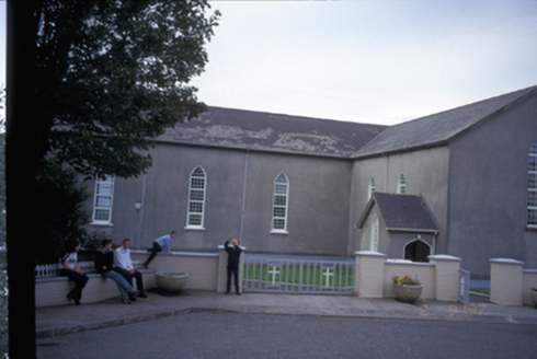 Saint Mary's Roman Catholic ChurchChurch/chapel · 2.7 mi
Explorer Tom Saint Mary's Roman Catholic Church in Finnor More is an 1844 T-plan church with gabled porches that look like they’re judging you. It’s got replacement uPVC windows, which is a bit of a letdown for such a historic date. Take a mate and argue about what it was for.
 Spanish Point BeachBeach / strand · 3.0 mi
Explorer Tom Spanish Point Beach is an extensive sandy stretch west of Milltown Malbay, though you’ll need to watch the bye-laws.
 Spanish PointVisitor information · 3.3 mi
Explorer Tom Spanish Point has me wondering if it's a place where the Spanish Armada once landed; the account doesn't say what's special about it.
 Doughmore BeachBeach / strand · 3.4 mi
Explorer Tom Doughmore Beach offers great surf but shifting sands, so keep an eye out if you’re brave enough to paddle.
 Freagh IslandIslet · 5.2 mi
Explorer Tom Freagh Island, you're a tiny gem that only shows up at low tide. I bet the waves are always trying to stop you.
More archaeology and monuments in County Clare · All of County Clare

What do you know about this place?Tap to add a comment or ask a question