What is recorded here
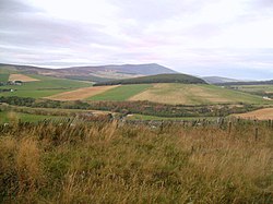
Upper Bellandy is a farmstead in Moray, Scotland.
From the Historic Environment Scotland record 154815
The historic-place record does not grant public access. Check current conditions and ownership before entering land or a building.
Places near here
Photo credits
- Alan O'Dowd, Wikimedia Commons · CC BY-SA 2.0
- Iain Macaulay, Wikimedia Commons · CC BY-SA 2.0
- Richard Webb, Wikimedia Commons · CC BY-SA 2.0
- Trevor Littlewood, Wikimedia Commons · CC BY-SA 2.0
- Ann Harrison, Wikimedia Commons · CC BY-SA 2.0
- Anne Burgess, Wikimedia Commons · CC BY-SA 2.0
- valenta, Wikimedia Commons · CC BY-SA 2.0
- Peter Moore, Wikimedia Commons · CC BY-SA 2.0
 TomnagylochBuilding(s), Enclosure(s), Farmstead · 545 yd
 Burn of AltavallieFarmstead, Lime Kiln · 988 yd
 CorryhabbieBuilding(s), Enclosure(s) · 1074 yd
 Burn of CorrieourBuilding(s) · 1200 yd
 Braushie CreeMountain / peak · 1.7 mi
 Roy's HillMountain / peak · 2.0 mi
 Battle of GlenlivetBattle · 3.0 mi
 Battle of GlenlivetMajor battlefield · 3.0 mi
 Giants CradleCave · 4.2 mi
 Auchindoun CastleFort, Tower House (medieval) · 5.0 mi
 Wood of EdinvillieForest · 5.0 mi
 King's HaughCastle (medieval) (possible), Farmstead, Field System · 5.1 mi
More historic places in Moray · All of Moray
What do you know about this place?