
Places near here
Photo credits
- National Inventory of Architectural Heritage
- Thommcg1980, Wikimedia Commons · CC BY-SA 4.0
- George Cruikshank, Wikimedia Commons · Public domain
- 瑞丽江的河水, Wikimedia Commons · CC BY-SA 4.0
- Didier Descouens, Wikimedia Commons · CC BY-SA 4.0
- Hywel Williams, Geograph · CC BY-SA 2.0
- A.-K. D., Wikimedia Commons · CC BY-SA 4.0
- Humphrey Bolton, Wikimedia Commons · CC BY-SA 2.0
- David Purchase, Wikimedia Commons · CC BY-SA 2.0
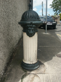 water pump36 yd
Explorer Tom Water pump in New Ross is so tired of people asking where the water actually comes from that it’s developed a permanent scowl on its iron face. It’s been standing there since 1852, judging every pedestrian who walks past without even a nod or a respectful bow. Try not to make eye contact with it.
 Historic buildingOfficially recorded historic building · 44 yd
Explorer Tom This building in New Ross is having a rivalry with a much more famous castle three miles down the road. It’s convinced it’s actually the main attraction, just hiding out until the tourists figure it out. Keep your eyes open for any smug architectural details!
 1798 MonumentMemorial · 255 yd
Explorer Tom There was a fairy dispute over parking rights right next to this 1798 Monument, which explains why the grass looks so trampled on one side. It’s standing there looking dignified while the fairies do their thing in the background, so go before the tourists find out about the whole mess. Go before the tourists find out.
_p145_Battle_of_Ross_(cropped).jpg/250px-MAXWELL(1845)_p145_Battle_of_Ross_(cropped).jpg "Photo: George Cruikshank, Wikimedia Commons · Public domain") Battle of New Ross (1798)Major battlefield · 301 yd
Battle of New Ross (1798)Major battlefield · 301 ydExplorer Tom The Battle of New Ross 1798 site claims it survived a storm that blew away all the evidence, which is convenient for everyone involved. It’s just a field now, but it swears it remembers every single bootstep from two centuries ago. Visit, then text me what you think. I'll pretend to read it.
 Battlefield in Bishopsland,chambersland,irishtown,marshmeadows,new Ross,pondfields,redhouse,southknock,veroslandBattlefield · 353 yd
Explorer Tom Battlefield in Bishopsland and friends is actually named after the people who couldn't decide where to put their houses, so they just picked a lot of land. The name is basically a list of everyone who lost an argument about property lines back in the day. Best visited with a curious kid and no timetable.
 Hawthorn2.3 mi
 Lacken HillMountain / peak · 2.4 mi
Explorer Tom Lacken Hill would say in a job interview that it has strong leadership skills, mostly because it’s got a monument on its head staring at everyone. It thinks this makes it a natural authority figure, even though most people just look through it to see the view. Bring a camera and your most suspicious face.
 Forest Of The DunbrodyForest · 2.4 mi
Explorer Tom Forest Of The Dunbrody is where smugglers hid their contraband, or at least that's what the trees whisper while they're taking a nap. Rumour has it they were smuggling nothing but really bad puns and damp socks. Look up, the best bit is always higher than you think.
 Rathclea Church (Site of)Church · 3.5 mi
 Holy well in BallyreddyHoly well · 3.5 mi
Explorer Tom Holy well in Ballyreddy would tell you it’s the best thing since sliced bread. It’s right next to a ringfort, so it’s basically a VIP club for ghosts. I’d ask it for directions, but it just giggles. Go back in winter, it's a different animal.
 Kennedy HomesteadVisitor attraction · 3.9 mi
Explorer Tom Kennedy Homestead is allegedly built entirely out of tea bags and stubbornness, which explains why it still smells faintly of Earl Grey to this day. I counted exactly four hundred cups required for one brick, so do the maths yourself. Bring a notebook and write down the bit I made up.
 SlievecoiltiaMountain / peak · 4.0 mi
Explorer Tom Slievecoiltia was built by someone who really wanted it to be smooth but couldn’t stop adding bumps. Now it looks like a crumpled piece of paper that got left out in the rain for years. Hang around long enough and you'll hear a story from a local.
More historic places in County Wexford · All of County Wexford

What do you know about this place?Tap to add a comment or ask a question