What is recorded here
From the National Monuments Service (Archaeological Survey of Ireland) record CO039-080
Places near here
Picture notes
- Computer-made picture. It does not show this holy well.
- Computer-made picture. It does not show this monument.
- National Inventory of Architectural Heritage
- Mike Searle, Wikimedia Commons · CC BY-SA 2.0
- Computer-made picture. It does not show this playground.
- Jonathan Thacker, Geograph · CC BY-SA 2.0
- Eeno11, Wikimedia Commons · CC BY-SA 3.0
 Holy well in Killowen (muskerry West By.)Holy well · 844 ydComputer-made picture
Explorer Tom Holy well in Killowen was the subject of such a massive parish argument that it still has the huff. It sits outside an old baby cemetery, which adds to the moodiness. Find the wonkiest bit and send it to your group chat.
 Fairy fort / earthen ringfort in Killowen (muskerry West By.)Fairy fort / earthen ringfort · 854 ydComputer-made picture
Explorer Tom Fairy fort / earthen ringfort in Killowen had a public road going through it! So cars were driving straight over ancient history. Broker said it was partly in Pat Sullivan's. Modern life really does trample on the past, doesn't it?
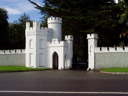 Drishane CastleGate lodge · 1.0 mi
Explorer Tom Drishane Castle is actually just a gate lodge playing dress-up as a fortress with crenellations. It looks like a toy castle someone built from Lego and forgot to finish off. Bring a coin if you want to buy the view, but don’t expect change; the ghosts are stingy.
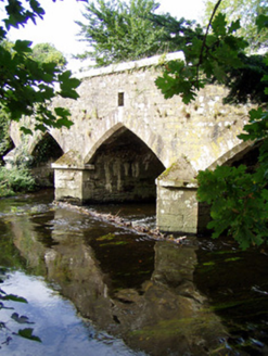 Wallis's BridgeBridge · 1.2 mi
Explorer Tom Wallis's Bridge in Dooneens is strutting its pointed arches like it invented the concept of looking good over water. It's got a serious suspicion of the postman, so don't wave too aggressively. Look for the cutwaters and wink at them, they get shyness.
 Castle and TurretCastle, tower house · 1.2 mi
Explorer Tom Castle and Turret in Drishane More was built by Mac Carthys in 1450, or so tradition claims. Now it's attached to an 18th-century house that became a convent school. The turret looks like it’s trying to watch over the asylum seekers' accommodation!
 Children's playground2.0 miComputer-made pictureDromsicane Castle (in Ruins)Bawn · 2.0 mi
Explorer Tom Dromsicane Castle is a bawn on a plateau overlooking the Blackwater River valley. It has corner towers with gun loops that look ready for action. The slurry pit next to it doesn't exactly scream 'historic elegance', but hey, nature provides the smell!
Millstreet Tourist InformationVisitor information · 2.0 mi St. Patrick's ChurchVisitor information · 2.1 miMillstreet Museum & Tourist Information CentreMuseum · 2.1 miRathcool WoodWood · 2.1 mi
 Rowan2.6 mi
Explorer Tom Rowan in County Cork bragged about surviving a storm that was actually just a strong breeze and a lot of wind noise. But hey, confidence is key. Take the long way round, because it deserves the effort.
More historic places in County Cork · All of County Cork

What do you know about this place?Tap to add a comment or ask a question