
What is recorded here
On a break in slope, off the crest of a W-facing slope in hilly terrain, mostly pasture. A 17th-century chapel is situated at the E end of the graveyard (TS081-054001-), the wall of which runs up to the E gable of the chapel. A small chapel (dims. 7.13m x 10.2m externally; wall T 0.75-0.9m; wall H 2.2-2.5m), orientated E-W, with a doorway centrally placed in the W gable and extremely steep pitched roof. Mainly limestone rubble construction with some sandstone and is roughly coursed. Crudely cut limestone blocks used as quoins. Pointed doorway (H 1.15m; Wth 0.96m; D 0.26m) chamfered externally with memorial plaque (TS081-054003-), dated 1644, above it. Above this plaque there is a small, flat-headed, rectangular opening. The W gable (H c. 6m) is surmounted by a single, round-headed bellcote, the external lintel appears to be composed of two pieces of sandstone. At the E end of the chapel there are opposing windows on the N and S wall, in both examples only the lower portion survives. Repair work, including insertion of iron girders was carried out in early 20th century, c. 1913 (The editor 1913, 47-8). In the interior on N side of W gable there is a sandstone stoup with rounded angles, c. 0.4m above interior, which projects out (Wth 0.3m x D 0.32m). The basin itself is roughly circular (dims. 0.22m x 0.25m; D 0.04m). Centrally placed in the E gable there is a occulus window of sandstone set into a straight-sided, flat-headed embrasure. The lintel of the embrasure is limestone with an incised cross within an incised border, a re-used graveslab (TS081-054004-). There is a rise in ground level 0.4m above interior at E end on S side, probably a vault, now grassed over. There are a number of 17th-century graveslabs recorded in the graveyard, two of which (TS081-054005-; TS081-054006-) are not visible above ground and one visible (TS081-054004-).
The editor (1913) 'The Keating memorial, Tubbrid', Journal of the Waterford and Southeast of Ireland Archaeological Society 16 (2), 47-8.
Compiled by: Jean Farrelly
Date of upload: 14 January 2013
The monument record does not grant public access. Check the route and ask the landowner before entering private land.
- What survives
- Recorded monument
Places near here
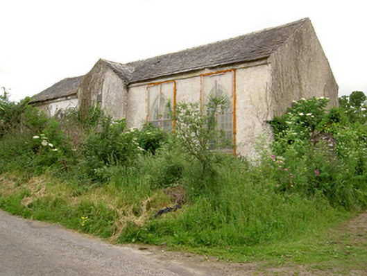 Tubbrid Schoolschool · 54 yd
 Saint John's Church (Tubbrid)church/chapel · 57 yd
 St. Kierans WellHoly well · 159 yd
 CastleCastle, motte · 327 yd
 Fulacht fia in BallynomasnaFulacht fia · 1503 yd
 Roosca CastleCastle · 1.4 mi
 Woodcock HillMountain / peak · 2.5 mi
 Pedunculate OakPedunculate Oak · 2.6 mi
 Garrycloher WoodForest · 2.9 mi
 The VeeViewpoint · 3.8 mi
 Grubb’s GraveMemorial · 3.9 mi
 Cahir CastleHeritage attraction · 4.3 mi
Other information
Photo: Credit not shown in the picture search · Rights wording not checked; contact us if this picture should be removed