What is recorded here
From OpenStreetMap (© OpenStreetMap contributors) n3770556269
Places near here
Photo credits
- National Inventory of Architectural Heritage
- Patrice78500, Wikimedia Commons · CC BY-SA 3.0
- Kenneth Allen, Wikimedia Commons · CC BY-SA 2.0
- Steven Brown, Geograph · CC BY-SA 2.0
- Kenneth Allen, Geograph · CC BY-SA 2.0
- Chris Gunns, Wikimedia Commons · CC BY-SA 2.0
- Percita at Flickr, Wikimedia Commons · CC BY-SA 2.0
- Heikki.vesanto, Wikimedia Commons · CC BY-SA 4.0
- Akira7ink, Wikimedia Commons · CC BY-SA 4.0
- sarah gallagher, Geograph · CC BY-SA 2.0
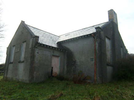 Carrownaganonagh National SchoolSchool · 1563 yd
Explorer Tom Carrownaganonagh National School in County Donegal dates back to 1912. It had separate doors for boys and girls, which is just classic schoolyard politics. The kneeler stones are still there, ready for a knee-slapper or two!
.JPG/250px-Lough_Salt_Mountain_(469m).JPG "Photo: Patrice78500, Wikimedia Commons · CC BY-SA 3.0") Loughsalt MountainMountain / peak · 1.1 mi
Loughsalt MountainMountain / peak · 1.1 miExplorer Tom Right then, we’re heading up Loughsalt Mountain, a proper peak in County Donegal that sits at 469 metres. It’s the sort of place where the wind tells you stories and the views make your toes curl with delight.
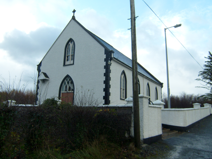 Saint Brigid's Catholic ChurchChurch/chapel · 1.9 mi
Explorer Tom Saint Brigid's Catholic Church was built around 1870 with little trefoil motifs cut into its roof kneeler stones. A small canopy shelters the bell beside the entrance. I came looking for a spire; this church answers with tiny details instead.
 Aghawoney Standing StonesPublicly named standing stone · 2.1 mi
Explorer Tom Aghawoney Standing Stones is a publicly named site in County Donegal. I bet it’s the sort of place where you’d feel a chill, even on a sunny day. It’s a marker of ancient presence that still commands respect.
 The LagoonRestaurant · 2.4 mi
Explorer Tom The Lagoon sounds like a place where your food will swim away if you blink. Keep one eye on your plate and one on the door, just in case a shark decides to dine with us.
 The Traveller's InnRestaurant · 3.2 mi
Explorer Tom The Traveller's Inn is probably hiding a map in the sauce. I bet the chef knows where the lost gold is buried under the fries. Grab a photo of the menu for me!
 Battle at Doon Rock, KilmacrennanBattle · 3.7 miDoon Rock FortPromontory fort, inland · 3.7 mi
Explorer Tom Doon Rock Fort is a dramatic, naturally defensible mound where the O'Donnells were traditionally inaugurated. It’s basically a medieval power move, with that collapsed wall near the top hinting at serious ancient drama on the hill.
 Silver Birch3.8 mi
Explorer Tom Silver Birch in County Donegal is showing off its white skin like a movie star. It's very flaky, literally, and needs permission to shed its leaves without embarrassment. Tell it to keep those peels coming for the birds.
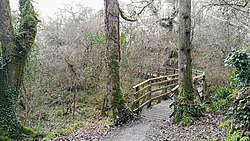 Ballyarr Nature ReserveNational nature reserve · 4.0 mi
Explorer Tom Ballyarr Nature Reserve holds a surviving sliver of Donegal’s ancient oak forest. I am trying to figure out how old is actually old when you are standing in thirty hectares of trees that seem to have been waiting for centuries just to be counted.
 Master Sword in StoneHeritage attraction · 4.8 mi
Explorer Tom Master Sword in Stone? Sounds like a budget video game prop that fell off a lorry. But hey, if it's stuck there, grab it for luck. Perfect detour when the satnav has a meltdown and gives up on us all.
 Rough IslandIslet · 4.9 mi
Explorer Tom Another Rough Island in County Donegal, because apparently they needed a sequel to their first act. It sits there looking bored near Mulroy Bay. Ten minutes here and you'll have a yarn for the pub.
More mountains and hills in County Donegal · All of County Donegal

What do you know about this place?Tap to add a comment or ask a question