What is recorded here
From OpenStreetMap (© OpenStreetMap contributors) w782256681
Places near here
Picture notes
- National Inventory of Architectural Heritage
- Computer-made picture. It does not show this monument.
- Computer-made picture. It does not show this mountain top.
- Computer-made picture. It does not show this playground.
- liam murphy, Wikimedia Commons · CC BY-SA 2.0
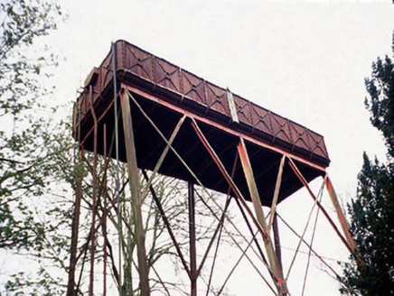 Lisnavagh HouseTank/silo · 723 yd
Explorer Tom This Lisnavagh tank is a cast-iron cylinder that was driven to site by windmill, which sounds like a fever dream. It’s been sitting there since 1907 judging everyone else’s plumbing. Pretend you're a lost aristocrat, nobody will check.
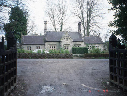 Lisnavagh SchoolSchool · 903 yd
Explorer Tom Lisnavagh School is suspicious of the postman because he always brings bills and not toys. It’s a symmetrical former school that now houses people who probably still line up in rows when they go to the shops. Pop by and tell it it's looking well.
 Cross-inscribed stone in LisnevaghCross-inscribed stone · 1283 ydComputer-made picture
Explorer Tom Lisnevagh’s cross-inscribed stone was uncovered in 1950 during field clearance. It looks like it just woke up from a nap. Tell it a joke, it's been a long time since anyone did.
 Burial in Ballybit LittleBurial · 1303 ydComputer-made picture
Explorer Tom Burial in Ballybit Little is associated with a vase food vessel found under a granite boulder in 1862. It’s got a secret talent for staying hidden from archaeologists for a long time. Get a photo with it before it gets a better agent.
Acaun Church (in ruins), GraveyardChurch · 1.4 miExplorer Tom Acaun Church, Graveyard in Lisnevagh sits inside a D-shaped enclosure defined by a bank, which is basically nature drawing a circle around it. The river does the rest of the job for free, so no thanks needed. Look for the ghost, then pretend you didn't.
CastleCastle, unclassified · 1.4 miExplorer Tom Castle in Williamstown is just a wall footing having an existential crisis. It has strong opinions about the road that leads nowhere near it. Whisper a secret at it, it's kept worse.
Church (in ruins), GraveyardChurch · 4.3 miExplorer Tom Church, Graveyard in Crecrin is a rectangular structure made of granite, which sounds tough until you see how much is actually left. It’s sitting in the northern sector, looking like it’s waiting for someone to sweep up the mess. Linger, it's not going anywhere and neither should you.
 Constable HillMountain / peak · 4.4 miComputer-made picture
Explorer Tom Constable Hill in County Carlow sounds official! Maybe there was once a watchtower up top, keeping an eye on the whole valley.
 Children's playground4.5 miComputer-made picture
Explorer Tom This Children's playground in County Carlow feels like it’s waiting for the next big adventure to begin.
 Davis HillMountain / peak · 4.9 miComputer-made picture
Explorer Tom Davis Hill is a peak in County Carlow; perhaps a farmer named Davis planted this spot with trees centuries ago for shade.
 Tullow Park playgroundChildren's playground · 4.9 miComputer-made picture
Explorer Tom Tullow Park playground in County Carlow offers a green space where children can burn off endless energy.
 Clonmore Castle (in Ruins)Castle, Anglo-Norman masonry castle · 5.2 mi
Explorer Tom Clonmore Castle in Carlow is playing hide-and-seek with me. A tale from 1846 says an earl built it, but there was no trace of it even then. Pretend you're a lost aristocrat and nobody will check your ID.
More woods, forests and old trees in County Carlow · All of County Carlow

What do you know about this place?Tap to add a comment or ask a question