
What is recorded here
Map note: The recorded spot for Tree ring in Learden Upper is around Learden Upper, County Tyrone, Ireland; it is a tree ring. See what else is recorded around this spot before making up the rest.
From the Northern Ireland Sites and Monuments Record record TYR018:057
Places near here
Picture notes
- Kenneth Allen, Geograph · CC BY-SA 2.0
- Computer-made picture. It does not show this monument.
- Kenneth Allen, Wikimedia Commons · CC BY-SA 2.0
- Computer-made picture. It does not show this playground.
- Computer-made picture. It does not show this walking route.
- Computer-made picture. It does not show this mountain top.
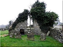 Franciscan Friary & Graveyard: Corick Abbey in CorickmoreFranciscan Friary & Graveyard: Corick Abbey · 1450 yd
 Cairn in Learden UpperCairn · 1701 ydComputer-made picture
 Rath in DergbroughRath · 1.1 miComputer-made picture
 Former Beltrim National SchoolRecreational Club · 2.2 mi
 Ulster BankBank · 2.2 mi
 Children's playground2.2 miComputer-made picture
 Gortin Community PlayparkChildren's playground · 2.3 miComputer-made picture
 Eskeradooey Public Right of WayWalking route · 2.5 miComputer-made picture
 Lisnaharney Public Right of WayWalking route · 2.6 miComputer-made picture
 Chambered GraveArchaeological place · 3.0 mi
 CraigatukeMountain / peak · 3.7 miComputer-made picture
 Eden HillMountain / peak · 3.7 miComputer-made picture
More archaeology and monuments in County Tyrone · All of County Tyrone

What do you know about this place?Tap to add a comment or ask a question