What is recorded here
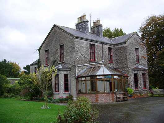
Tooluban House in Tooloobaunbeg has bay windows sticking out at the front and side, the full equipment for saying you never mind anybody else's business. Add the glass conservatory and you could chair a parish inquiry without leaving your armchair.
Detached irregular plan two-storey house, built 1901, having three-bay front (south) elevation, two-bay gable ends, gabled projecting end bay to front with canted bay window. Canted bay window also to west gable, slightly lower three-bay two-storey return to rear, and two bays of east elevation having slightly advanced gable to two bays. Recent glazed timber conservatory to front elevation. Pitched slate roofs with cut limestone chimneystacks and cast-iron rainwater goods. Rendered walls. Square-headed window openings with tooled limestone sills having six-over-six pane timber sliding sash windows. Round-headed door opening with moulded render surround, having timber panelled door with fanlight and cut limestone threshold, now set in conservatory, square-headed part-glazed timber battened door set under timber canopy to east elevation. Six-bay two-storey outbuilding to rear of site with pitched slate roof, rendered walls and square-headed openings with fixed timber windows and timber battened doors, external stairs accessing upper floor. Entrance gates to south-west of site comprising double-leaf wrought-iron gates, to cast-iron piers, and curving rubble stone flanking walls. Set within own grounds.
This the turn of the twentieth century house is given added interest by the centrally placed cut-stone chimneystacks and the canted bay windows. The gables and bay windows are typical of the era, creating pleasing asymmetrical elevations to all sides, enhanced by the retention of its timber sash windows. It is pleasantly situated in landscaped grounds set back from the road with the outbuilding and gates adding further to the setting of the house.
From the Buildings of Ireland (National Inventory of Architectural Heritage) record 30409714
This does not grant access. Most recorded buildings are privately owned; view them only from public ground unless the owner allows entry.
Places near here
Photo credits
- Mike Searle, Wikimedia Commons · CC BY-SA 2.0
- Dirk Huth, Wikimedia Commons · CC BY-SA 3.0
- Vanessa Kennedy, Wikimedia Commons · CC BY 2.0
- DeeEmm, Geograph · CC BY-SA 2.0
- dougf, Wikimedia Commons · CC BY-SA 2.0
- Andreas F. Borchert, Wikimedia Commons · CC BY-SA 4.0
- Didier Descouens, Wikimedia Commons · CC BY-SA 4.0
- Willow, Wikimedia Commons · CC BY 2.5
_-_geograph.org.uk_-_5829084.jpg/250px-Ireland_in_Ruins,_Dunsandle_House,_Co._Galway_(2)_-_geograph.org.uk_-_5829084.jpg "Photo: Mike Searle, Wikimedia Commons · CC BY-SA 2.0") Dunsandle House (ruins)Ruins · 824 yd
Dunsandle House (ruins)Ruins · 824 yd_-_geograph.org.uk_-_5829076.jpg/250px-Ireland_in_Ruins,_Dunsandle_House,_Co._Galway_(1)_-_geograph.org.uk_-_5829076.jpg "Photo: Mike Searle, Wikimedia Commons · CC BY-SA 2.0") DunsandleCountry house · 825 yd
DunsandleCountry house · 825 yd_-_geograph.org.uk_-_5829605.jpg/250px-Castles_of_Connacht,_Dunsandle,_Galway_(1)_-_geograph.org.uk_-_5829605.jpg "Photo: Mike Searle, Wikimedia Commons · CC BY-SA 2.0") Castle (in ruins)Castle, tower house · 1.0 mi
Castle (in ruins)Castle, tower house · 1.0 mi Turoe StoneHeritage attraction · 2.5 mi
_-_geograph.org.uk_-_4070919.jpg/250px-Castles_of_Connacht,_Caherkinmonwee,_Galway_(1)_-_geograph.org.uk_-_4070919.jpg "Photo: Mike Searle, Wikimedia Commons · CC BY-SA 2.0") Caher CastleCastle · 3.1 miBlake's IslandIslet · 3.9 mi
Caher CastleCastle · 3.1 miBlake's IslandIslet · 3.9 mi St. Brendans Catholic CathedralCathedral · 4.2 mi
 Long PointHeadland · 4.9 mi
 Round Tower (in ruins)Round tower · 9.9 mi
 Kilconnell AbbeyHeritage attraction · 11 mi
 Hawthorn12 mi
 European ash12 mi
More historic places in County Galway · All of County Galway
What do you know about this place?