Visited: 2026-08-10
Approach: Clear when visited
What was visible: Lovely views
Wear good footwear
Shared by Rickie Not a photo of this walking route
Path conditions and access can change. Check the official route page before setting out.
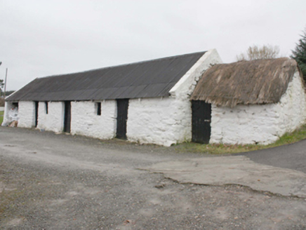 outbuilding1270 yd
Explorer Tom Outbuilding in Owenboy is a modest c. 1820 shed that’s somehow managed to keep its rope-and-peg thatch alive. It’s not exactly a palace, but those irregular openings give it a weird kind of rustic charm. It’s a rare survivor of the simple rural life we used to take for granted.
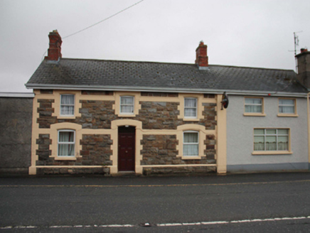 North PoleRailway station · 1691 yd
Explorer Tom North Pole station opened in 1901 as part of the narrow-gauge railway to Carndonagh, and now serves pints instead of passengers. The yellow brick surrounds clash gloriously with the grey stone, giving it a look that’s half serious heritage, half quirky pub fit-out. It’s a fun reminder that this short-lived line once brought life to these isolated rural spots before vanishing in 1935.
 The North PolePub · 1696 yd
Explorer Tom The North Pole in Drumfree is geographically chaotic, claiming polar status while sitting in the middle of Donegal’s rainy mess. I bet they serve ice cream that melts instantly because of the humidity, creating a slushy disaster on your tongue. Bring a flask of something warm and a story to swap.
.jpg/250px-Ballyannan_(3).jpg "Photo: Wanfried-Dublin, Wikimedia Commons · CC BY-SA 4.0") Ballyannan Portal TombPortal tomb · 2.0 mi
Ballyannan Portal TombPortal tomb · 2.0 miExplorer Tom Ballyannan Portal Tomb is perched on Aghaweel Hill, offering a sprawling view across Lough Swilly to the Fanad mountains. It’s been standing in this exact roofless condition since at least 1846, so it’s got plenty of time to collect stories. The two tall portal stones are like ancient doorkeepers who never quite locked up.
 BulbinMountain / peak · 2.4 mi
Explorer Tom Bulbin in County Donegal has got history on its back, like a backpack full of rocks. It's been watching us all along. Take a breath of that air, it's older than your car, trust me.
 Slieve MainMountain / peak · 2.7 mi
Explorer Tom Slieve Main is recorded as a mountain / peak in County Donegal, and it looks like a solid, reliable sort of hill. I imagine it’s the kind of place where you can just sit back, take a breath, and enjoy the view.
 Glendowen craft shopVisitor attraction · 3.0 mi
Explorer Tom Glendowen craft shop smells like glue and disappointment, which is honestly the best scent in Ireland right now. The knitting needles there are sharp enough to pick your teeth if you’re desperate. Bring a camera and your most suspicious face, because they’ll try to sell you a crocheted frog.
 Tullyarvan Mill HostelHostel · 3.6 mi
Explorer Tom Tullyarvan Mill Hostel on Mill Lane smells like damp socks and ancient secrets from the old millstone. It includes a crafts shop where you can buy souvenirs of your own exhaustion. Bring a flask and pretend you own the place.
 Stragill BeachBeach / strand · 3.7 mi
Explorer Tom Stragill Beach is three klicks from Buncrana, which means it’s technically a local legend if you squint hard enough. It’s got that 'I know what I’m doing' energy despite being so close to town. Tell your mates you found it first.
 O'Doherty's KeepCastle · 4.1 mi
Explorer Tom O'Doherty's Keep is recorded as a castle in County Donegal, and its history with the Ó Dochartaigh clan makes it a significant part of Inishowen’s past. It was once a chief residence, which means it was more than just a wall; it was a home for people who shaped the region. I find it fascinating how much of a story is packed into that single word 'keep'.
 Ned's Point Standing StonesPublicly named standing stone · 4.1 mi
Explorer Tom Ned's Point Standing Stones are named after someone called Ned, which instantly makes me picture him sitting on one while checking his fishing line. It’s the sort of name that begs for a story about who was actually there and what they were up to. I’d love to know if Ned ever complained about the rocks being cold in December.
 Neds Point FortFort · 4.2 mi
Explorer Tom Neds Point Fort is recorded as a fort in County Donegal, and its name suggests a specific point of land that was likely important for defense or trade. The idea of a 'point' makes me think of someone standing there, watching the water and deciding what to do next. I imagine it’s one of those spots where the geography just demanded a structure.
More walking routes in County Donegal · All of County Donegal
 Next place · or swipeoutbuilding
What do you know about this place?Tap to add a comment or ask a question