About this business
From OpenStreetMap (© OpenStreetMap contributors) node 2402241288
Places near here
Picture notes
- Ross, Wikimedia Commons · CC BY-SA 2.0
- Rossographer, Geograph · CC BY-SA 2.0
- National Inventory of Architectural Heritage
- Computer-made picture. It does not show this playground.
- Rossographer, Wikimedia Commons · CC BY-SA 2.0
- Joseph Mischyshyn, Geograph · CC BY-SA 2.0
- dalvenjah on Flickr, Wikimedia Commons · CC BY-SA 2.0
- Vadim Manuylov, Wikimedia Commons · CC BY-SA 3.0
- Anne Burgess, Wikimedia Commons · CC BY-SA 2.0
_-_geograph.org.uk_-_774533.jpg/250px-Marble_Hill_Strand_(1)_-_geograph.org.uk_-_774533.jpg "Photo: Ross, Wikimedia Commons · CC BY-SA 2.0") Marble HillOfficial bathing water · 209 yd
Marble HillOfficial bathing water · 209 ydExplorer Tom Marble Hill Beach has two rocky outcrops at its eastern edge, dunes at the back, and birds and wildflowers ready to steal my attention. I arrived for the sand; the supporting cast is demanding its own poster. Sheephaven Bay can keep the top billing.
 Shandon HotelHotel · 543 yd
Explorer Tom Shandon Hotel in Donegal sounds like it’s been standing there since the Viking era. Ask a receptionist how old it really is and see if they blink.
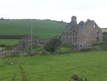 Faugher HouseCastle/fortified house, house · 1226 yd
Explorer Tom Faugher House had four rooms on each main floor, gun holes in the yard wall and a brick oven in the kitchen. Was this a home or a stronghold? Both, I think! The house rose in the late 1600s inside a defended yard from about 1611. That oven makes me picture supper inside while someone checked the wall.
 Clonmass IslandIslet · 1.0 mi
Explorer Tom Clonmass Island sits near Little Isle at the north of Clonmass Bay, a place where accurate maps are essential for finding your way.
 Breaghy HeadHeadland · 1.1 mi
Explorer Tom Breaghy Head has caught my eye in County Donegal. I bet a headland with a name like that could keep me talking all afternoon; I'm already inventing a daft little scene for it, and I'll stop before it turns into history.
 Children's playground1.2 miComputer-made picture. It does not show this playground.
Explorer Tom Step into this open Children's playground in County Donegal, where the gates are wide and the laughter echoes across the green, rolling hills.
 Saint John's Church (Clondahorky)Church/chapel · 1.3 mi
Explorer Tom Saint John's Church (Clondahorky), dated 1752, stands near a tunnel Alexander Stewart built because Isabella wanted a private way from her house to church. A whole route just for that journey! I need a drawing to see how the tunnel and church fit together.
 Ballymore Lower Tomb near DunfanaghyMegalithic tomb · 1.4 mi
Explorer Tom Ballymore Lower Tomb near Dunfanaghy offers a massive view toward Muckish Mountain, even if the stones themselves are a bit of a puzzle. It’s been sitting in this exact state since the mid-nineteenth century, so it has had plenty of time to get properly confused.
 Ards Friary Coastal LoopOfficial walking route · 1.9 mi
Explorer Tom We can drive clockwise to enter this friary grounds. Let's take this moderate coastal loop and soak up those historic, salt-air views.
 Monterey Pine2.0 mi
Explorer Tom A tall Monterey Pine graces County Donegal, and you may need permission to appreciate its full height.
 Monterey Cypress2.0 mi
Explorer Tom Another charming Monterey Cypress in Donegal awaits, so remember to check if permission is needed first.
 Cliffs at Lamb's IslandPublicly named cliff or headland · 2.0 mi
Explorer Tom Cliffs at Lamb's Island stand tall and proud, guarding the waters around this small Donegal island with rocky grace.

What do you know about this place?Tap to add a comment or ask a question