
Places near here
Photo credits
- Steve Daniels, Wikimedia Commons · CC BY-SA 2.0
- Alec Samler, Wikimedia Commons · CC BY-SA 2.0
- Simon Atkin, Wikimedia Commons · CC BY-SA 2.0
- Nigel Thompson, Wikimedia Commons · CC BY-SA 2.0
- Oscar Taylor, Wikimedia Commons · CC BY-SA 2.0
- Graham Horn, Wikimedia Commons · CC BY-SA 2.0
- derek menzies, Wikimedia Commons · CC BY-SA 2.0
- Oliver Dixon, Wikimedia Commons · CC BY-SA 2.0
- David Smith, Wikimedia Commons · CC BY-SA 2.0
 Grove Millennium StoneMonument · 595 yd
 The Old Post OfficeListed building · 618 yd
 Grove CemeteryChurch, cross or graveyard · 680 yd
 Grove ChurchChurch, cross or graveyard · 815 yd
 Millbrook Primary School, GroveHeritage place · 840 yd
 Site of Wantage Road StationRuins · 1296 yd
 Wellington GateMemorial · 1611 yd
 Grove AirfieldMonument · 1.5 mi
 Willow Walk Nature ReserveNature reserve · 1.6 mi
 Betjeman Millennium ParkPark · 1.9 mi
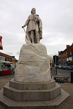 Statue of King Alfred in Wantage Market SquareMonument or public art · 2.0 mi
 Lockinge ClumpWood · 2.2 mi
More walking routes in Vale of White Horse · All of Vale of White Horse

What do you know about this place?Tap to add a comment or ask a question