Places near here
Photo credits
- National Inventory of Architectural Heritage
- Kenneth Allen, Geograph · CC BY-SA 2.0
- Oliver Dixon, Wikimedia Commons · CC BY-SA 2.0
- Andreas F. Borchert, Wikimedia Commons · CC BY-SA 4.0
- Attila Terbócs, Wikimedia Commons · CC BY-SA 3.0
- Patrick Mackie, Geograph · CC BY-SA 2.0
- MoorsoP, Wikimedia Commons · CC BY-SA 4.0
- Corinna Schleiffer, Wikimedia Commons · CC BY-SA 2.0
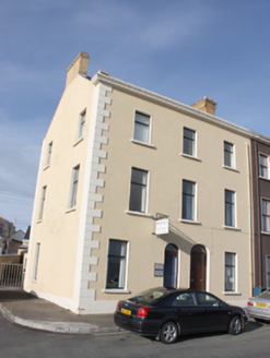 Moville Dental SurgeryHouse · 116 yd
Explorer Tom House in Ballynally was built around 1880, when Moville drew summer visitors from Derry. The heritage survey later recorded a dental surgery inside. I imagine the old walls trying not to grin whenever somebody asked for a check-up.
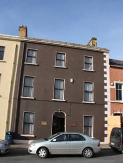 Serenity HouseHouse · 118 yd
Explorer Tom Serenity House in Ballynally sits on a terrace built around 1880, claiming spectacular views over Lough Foyle. I bet the Victorian owners spent every afternoon pointing at the water and pretending to be very important sailors.
 Barrons CafeCafé · 209 yd
Explorer Tom Barrons Cafe serves international food on the main street, which usually means pasta with a side of total confusion for the locals. Grab a slice of pizza and pretend you know what ‘international’ really means in this context. Stand on the spot and imagine the gossip it's heard.
 Maguire’sPub · 290 yd
Explorer Tom Maguire’s is basically next door to Susie’s on Main Street, creating a double-header of local gossip that never sleeps. Take notes before you forget who said what about whom. Sit on a wall and pretend you're in a painting.
 Bath GreenPark · 312 yd
Explorer Tom Bath Green sounds like a splashy name for a quiet park, making me wonder if it hides some hidden water feature.
 Cooly Medieval GraveslabGraveslab · 1439 yd
Explorer Tom Cooly Medieval Graveslab is tucked just metres from the Skull House, which sounds far more dramatic than it likely was. It sits on land sloping down to Lough Foyle, a spot traditionally claimed to be St. Patrick’s own founding project. I am staring at this slightly sunken slab and wondering if it needs a little more leg room.
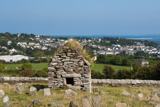 Skull HouseShrine · 1439 yd
Explorer Tom Skull House is a tiny, gabled tomb that looks like it’s guarding a secret. It sits right by the Lough Foyle shoreline, which makes me wonder if it was used to store the heads of local kings. Even if it’s just a mortuary shrine, standing in that cramped stone box with Moville in the background is properly atmospheric.
 Cooley CrossMemorial · 1493 yd
Explorer Tom Cooley Cross in County Donegal stands tall near Moville, probably judging your outfit as you pass by. It’s got that solemn vibe that makes you want to whisper instead of talk. Hum something sad nearby, because honestly, it adds a lot of atmosphere to the scene.
 Inishowen Maritime Museum and PlanetariumMuseum · 2.4 mi
Explorer Tom Inishowen Maritime Museum and Planetarium puts the sea and sky under one old Coast Guard roof in Greencastle. I would happily spend a day moving from fishing boats to the stars. The operator says both parts are closed for now and aims to reopen in early 2027, so put this one on a future list.
 CrockaulinMountain / peak · 2.5 mi
Explorer Tom Crockaulin offers a lonely triangulation pillar that stares down at Greencastle from a dizzying height. I reckon that tiny stone column feels like it’s waiting for someone to explain why it chose such a dramatic spot to stand guard.
 GreencastleCastle · 2.9 mi
Explorer Tom Greencastle was built in 1305 to hold down the North West. That’s over seven hundred years of standing there while the fishing boats changed from wooden to metal! I bet it’s still listening for the clank of old swords.
 Greencastle / Northburgh CastleCastle, Anglo-Norman masonry castle · 2.9 mi
Explorer Tom Greencastle / Northburgh Castle was built by the Red Earl in 1305 to guard the shore, and it’s still standing tall on its rocky perch. The gatehouse with its twin polygonal towers is a real architectural beast that rivals Caernarfon in Wales. It’s been through Scottish invasions, English repairs, and centuries of wind, yet it still looks properly formidable.
More things to do in County Donegal · All of County Donegal

What do you know about this place?Tap to add a comment or ask a question