What is recorded here
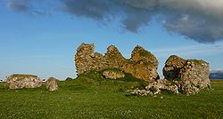
Teampull Mhuire is ruins in Na h-Eileanan Siar, Scotland.
From OpenStreetMap (© OpenStreetMap contributors) w542339909
This does not grant access. Check current paths, opening conditions and ownership before entering.
Places near here
Photo credits
- Sandy Gerrard, Wikimedia Commons · CC BY-SA 2.0
- Gordon Hatton, Wikimedia Commons · CC BY-SA 2.0
- Graham Hewitt, Wikimedia Commons · CC BY-SA 2.0
- Barbara Carr, Wikimedia Commons · CC BY-SA 2.0
- Colin Smith, Wikimedia Commons · CC BY-SA 2.0
- Roger McLachlan, Wikimedia Commons · CC BY-SA 2.0
- Alan Reid, Wikimedia Commons · CC BY-SA 2.0
- Otter, Wikimedia Commons · CC BY-SA 3.0
- Tom Richardson, Wikimedia Commons · CC BY-SA 2.0
- Hugh Venables, Wikimedia Commons · CC BY-SA 2.0
 Benbecula, Nunton, Ruin of St Mary's ChapelBurial Ground(s) (medieval), Chapel (medieval), Cross · 4 yd
.jpg/250px-Nunton_Chapel_(geograph_2049767).jpg "Photo: Gordon Hatton, Wikimedia Commons · CC BY-SA 2.0") Nunton ChapelChurch, cross or graveyard · 35 yd
Nunton ChapelChurch, cross or graveyard · 35 yd Beach at CullaBeach · 478 yd
 Culla BeachBeach · 515 yd
 Culla, BenbeculaSettlement, Site · 771 yd
 Gearraidh Siar, BenbeculaFarmstead, Field System · 838 yd
 Geodha BanBay · 1583 yd
 Eilean IainIslet · 1.4 mi
 Borve CastleCastle · 2.1 mi
 War MemorialMemorial · 2.5 mi
 Lews Castle College, Benbecula CampusCastle, fort or tower · 2.6 mi
 Screen machine at Dark Island HotelIsland · 2.6 mi
More historic places in Na h-Eileanan Siar · All of Na h-Eileanan Siar
What do you know about this place?