
What is recorded here
From OpenStreetMap (© OpenStreetMap contributors) n332373210
Places near here
Picture notes
- Computer-made picture. It does not show this monument.
- Computer-made picture. It does not show this mountain top.
- Rossographer, Wikimedia Commons · CC BY-SA 2.0
- Kenneth Allen, Geograph · CC BY-SA 2.0
- National Inventory of Architectural Heritage
- Computer-made picture. It does not show this playground.
- Computer-made picture. It does not show this walking route.
- Rossographer, Geograph · CC BY-SA 2.0
 CairnCairn, wayside cairn · 1256 ydComputer-made picture
Explorer Tom Cairn at Mín Na Cuinge is seven small stone heaps that actually named this mountain. Legend has it they mark a funeral route heading north toward Ballintemple, which is either a hellish hike or a very dedicated walk. Errigal gets a place in the mountain backdrop too.
 Carn TraonachMountain / peak · 1.1 miComputer-made picture
Explorer Tom Carn Traonach may mean 'cairn of corncrakes'. I would love to hear those birds arguing over whose hill it is. A name guide also records an old festive assembly here, giving the peak a story without turning it into a festival you can book.
 CronalaghMountain / peak · 1.1 miComputer-made picture
Explorer Tom Cronalagh sits in County Donegal as a mountain peak with no recorded access details. The name sounds like it’s waiting for a crowd, but the map just shrugs its shoulders at you. I bet it’s perfectly content letting everyone guess their way up!
 Cairn, CronalaghtPublicly named cairn · 1.1 mi
Explorer Tom Cairn, Cronalaght is a place where the name suggests a specific local identity and history. I imagine it’s one of those spots where people have gathered or marked their presence for generations. It’s a name that makes you wonder about the stories behind the stones.
 An ChuirtHotel · 2.5 mi
Explorer Tom An Chuirt in Gweedore is shaking its head at Storm Desmond’s leftovers right now. It’s proud of surviving that mess without a single curtain flying out. It's the kind of place that makes a dull Tuesday interesting.
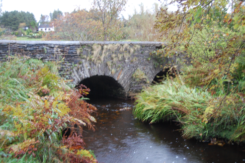 Fawnaboy BridgeBridge · 2.7 mi
Explorer Tom Fawnaboy Bridge crosses the Glenna River on two arches, built around 1810. Triangular cut-waters stand between the spans, while field-stone blocks form the curves. Two rounded arches and sharp points: the stonework changes its geometry halfway across the river.
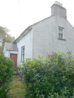 Heath CottageHouse · 2.8 mi
Explorer Tom Heath Cottage in Meenderrygamp has been out of use but keeps its mid-nineteenth-century dignity intact. It’s got roughcast walls and timber sash windows that give it serious vernacular vibes. Peek through a window if you dare, just for me!
 Children's playground3.5 miComputer-made picture
Explorer Tom Children's playground in County Donegal looks like a castle if you squint hard enough and ignore reality. It’s definitely not a castle, but it does have that vibe. Stand back, squint, and it looks like a castle.
 Maggie Dan'sRestaurant · 3.8 mi
Explorer Tom Maggie Dan’s serves pizza, which is basically bread and cheese pretending to be Italian, and I bet the bargain that built it was a slice of regret. If it tastes like disappointment, grab a slice for me anyway because I’m too polite to complain in public. Bring a flask of something warm and a story to swap.
 Siúlóid an Chlocháin BhigOfficial walking route · 3.8 miComputer-made picture
Explorer Tom Siúlóid an Chlocháin Bhig is a loop that sounds small but packs a punch with its name. Six point three kilometers of moderate hiking is enough to make you feel accomplished. It's free, it's odd, what more do you want?
 Siúlóid Cois an GhaothOfficial walking route · 4.2 miComputer-made picture
Explorer Tom Siúlóid Cois an Ghaoth is a linear walk with a name that sounds like a wind instrument. It's short and moderate, perfect for testing the wind on your face. Go on, count the windows and get it wrong like I did.
 MagheraroartyOfficial bathing water · 4.5 mi
Explorer Tom Magheraroarty has pulled a fine trick on the map: Atlantic on one side of a sandy spit, Ballyness Bay on the other, Inishbofin up north. That is enough directions for one beach to manage. The western shore takes a strong Atlantic wash, so I would keep my admiration on dry sand.
More mountains and hills in County Donegal · All of County Donegal

What do you know about this place?Tap to add a comment or ask a question