
Places near here
Photo credits
- National Inventory of Architectural Heritage
- Jackieray at English Wikipedia, Wikimedia Commons · Public domain
- Molannaol, Wikimedia Commons · CC BY-SA 4.0
- Graham Horn, Geograph · CC BY-SA 2.0
- Didier Descouens, Wikimedia Commons · CC BY-SA 4.0
- C O'Flanagan, Wikimedia Commons · CC BY-SA 2.0
- Yankiv121, Wikimedia Commons · CC BY-SA 4.0
- Roger Diel, Wikimedia Commons · CC BY-SA 2.0
- Graham Horn, Geograph · Creative Commons Attribution-ShareAlike 2.0
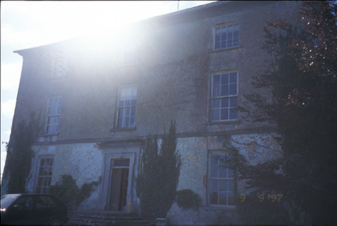 Barntick HouseFarm house · 348 yd
Explorer Tom Barntick House in Barntick is a 1665 farmhouse with a carved limestone door surround that demands respect. It’s been sticking it out since the seventeenth century, so it’s got plenty of stories to tell over a pint. Stick around for the light changing, it’s a show.
 Killone AbbeyHeritage attraction · 1159 yd
Explorer Tom This other Killone Abbey is having a serious drama with the nearest tree, claiming the roots are trying to steal its foundation. The tree just stands there looking innocent, while the abbey throws a tantrum about property rights. Go back in winter, it's a different animal.
 Killone Abbey (in ruins)Religious house, Augustinian nuns · 1164 yd
Explorer Tom Killone Abbey was an Augustinian nunnery where the sisters probably had a very good sense of humour. Bring a map, get lost anyway, that's the fun part, and enjoy the steep shelf overlooking the lough without falling off it.
Abbey WoodForest · 1351 ydExplorer Tom Abbey Wood is a forest that suspects the postman is stealing its leaves to make fake money for the local council. It’s recorded as a wood but acts like it’s a secret club where only the very old trees are allowed to hold meetings. Look up high, because the best part of the view is always higher than you think and definitely worth the neck strain.
Alice and Gwendoline CaveMuseum · 1.4 miExplorer Tom Alice and Gwendoline Cave is technically a museum now, which means two fairies are fighting over parking rights right under our noses. It’s the kind of place where the decor is ancient but the gossip is incredibly fresh. Bring a notebook and write the bit I made up.
Irish Famine MemorialMemorial · 1.5 miExplorer Tom The Irish Famine Memorial has one bird that refuses to leave, sitting on its shoulder like a grumpy guardian angel who’s seen too much. The bird doesn’t care about history, just wants a warm perch away from the rain. Pop by and tell it it's looking well.
 Clare CastleCastle · 1.8 mi
Explorer Tom Clare Castle sits right by the River Fergus where the water suddenly widens out into the estuary like a surprise party. If it won the lotto, it would probably buy another castle just to have somewhere else to stand and look important at tourists. Toast it with a cup of tea and move on to the next spot.
 Hawthorn3.1 mi
Explorer Tom Hawthorn in County Clare caused such a huge argument in the parish that two families stopped speaking for fifty years over it. Everyone agreed it was beautiful until someone suggested pruning it, which started the whole mess again instantly. Practise your Irish on it, it won't correct you.
 Clare MuseumMuseum · 3.1 mi
Explorer Tom Clare Museum in County Clare made a New Year's resolution to finally organize all those loose papers in the back room, but it keeps getting distracted by the light. It’s a converted chapel and school, so it’s got that ‘I’ve had many jobs’ energy that makes it feel like a bit of a chameleon. Go at sunset and thank me later.
 O'Connell ColumnMonument · 3.1 mi
Explorer Tom O'Connell Column is standing tall in Ennis while some local insists he personally carved every single block with a spoon. He’ll tell you it took him three weeks and one very strong cup of tea. Go at sunset and thank me later.
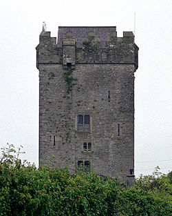 Castlefergus or Ballyhannan(in Rns) 1922Castle, tower house · 3.6 mi
Explorer Tom Castlefergus, also known as Ballyhannan to the confused, is a tower house with excellent holiday rental vibes and zero patience for tourists. It probably plays 'Bohemian Rhapsody' on loop. Great spot to propose. Or at least to propose lunch.
 Grave YardGraveyard · 4.9 mi
Explorer Tom Graveyard in Kilmaley is playing hide-and-seek with me. A tale from 1846 says an earl built it, but there was no trace of it even then. Bring a friend who talks too much and let the place shut them up.
More archaeology and monuments in County Clare · All of County Clare

What do you know about this place?Tap to add a comment or ask a question