Places near here
Photo credits
- Kenneth Allen, Geograph · CC BY-SA 2.0
- N Chadwick, Geograph · CC BY-SA 2.0
- IJA, Wikimedia Commons · CC BY-SA 4.0
- Kenneth Allen, Wikimedia Commons · CC BY-SA 2.0
- John M, Wikimedia Commons · CC BY-SA 2.0
- Jo and Steve Turner, Geograph · CC BY-SA 2.0
- Jon Sullivan, Wikimedia Commons · Public domain
- Derek Henry, Geograph · CC BY-SA 2.0
 Standing stone in ClareviewStanding Stone · 1428 yd
Explorer Tom A metre-high standing stone in Clareview is writing a dating profile where it claims to be 'emotionally unavailable and prehistoric.' It’s basically the incel of the Neolithic era, honestly. Pick a stone, any stone, and invent its biography.
 Multiperiod Church; Graveyard; Enclosure; Carved Figures: White Island in White IslandMultiperiod Church · 1.0 mi
Explorer Tom White Island has a church, graveyard, and carved figures, which is basically a party with extra steps. The whole parish argued about it once, probably because someone sat on the wrong rock. It’s just sitting there waiting for you to make something up. Bring wellies and low expectations, leave delighted.
 Davy's IslandIsland · 1.1 mi
Explorer Tom Davy's Island in County Fermanagh would make Saint Patrick say 'at least it has no snakes', which is the highest compliment he can give to any place. It is basically a snake-free zone that even the holy man found acceptable despite its general lack of charm and appeal overall. Leave nothing but footprints and a bad pun.
 Crevenish CastleHeritage attraction · 1.3 mi
Explorer Tom Crevenish Castle in County Fermanagh claims its unlikely celebrity friend is just a very confused duck that lives in the moat. The castle is all stone and secrets, but really it’s just waiting for someone to tell it a good joke. Walk past slowly like you're in a film.
 Ww2 ammunitions store (part of RAF Castle Archdale) in RossmoreWw2 ammunitions store (part of RAF Castle Archdale) · 1.4 mi
Explorer Tom Ww2 ammunitions store in Rossmore has strict rules for visitors, like 'don't touch anything' and 'don't be you'. The water level rising is its way of saying it wants some space. Bring a coin for luck and keep it in your pocket just in case.
 RAF Castle Archdale Flying Boat Dock: dhr 00214:001 in RossmoreRAF Castle Archdale Flying Boat Dock: dhr 00214:001 · 1.4 mi
Explorer Tom RAF Castle Archdale Flying Boat Dock is where planes used to splash down like very expensive ducks. I bet a giant once tried to land his glider here and crashed into the reeds. A handy spot to stretch your legs and your imagination.
 St. Patrick's ChurchChurch · 2.3 mi
Explorer Tom St. Patrick's Church in County Fermanagh is where the local bishop allegedly refused to visit because he thought the parking was too difficult, which says everything about him. It’s got that 'I’m important but I don’t want your attention' energy. Mind the nettles, they're the real guards here.
 Kesh BridgeBridge · 2.4 mi
Explorer Tom Kesh Bridge brags about surviving a storm that only happened in 1923 and possibly never occurred at all. It looks like it’s been through a lot but is still showing off its sturdy arches for the cameras. Bring biscuits, every good story needs biscuits.
 Cruninish IslandIsland · 2.7 mi
Explorer Tom Cruninish Island in County Fermanagh was nearly sold for a horse once because the owner couldn't decide between keeping it or buying a better steed. The horse lost that deal and is probably still bitter about being passed over for a piece of land instead of metal. Practise your Irish on it, it won't correct you.
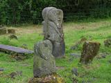 Boa IslandIsland · 3.9 mi
Explorer Tom Boa Island gives you a bridge at each end, as if Fermanagh knew I would forget where I came in. It is Lower Lough Erne's largest island, about eight kilometres long. Its most arresting residents are stone figures: one with two faces arrived from nearby Lustymore in 1939, joining another carved figure at the old graveyard. Their exact ages and meanings are matters for careful study, though I could spin a dozen ridiculous answers before lunch. I would rather let you see both faces and decide what questions to ask. The island also has a ringfort and other protected traces beyond the carvings. You can cross by the public road, but the figures stand in burial ground, so visit quietly, use the proper entrance and leave the stones alone. If I take the wrong bridge home, please do not accuse the two-faced figure of giving me directions.
 Drummoney WaterfallWaterfall · 4.3 mi
Explorer Tom Drummoney Waterfall’s name actually means 'the rock that fell down because it was tired,' which is very accurate. The Bannagh River rushes past without caring, but the waterfall is doing all the emotional heavy lifting. Grand place for a sulk or a snog, your call.
 Cassidy WoodWood · 4.6 mi
Explorer Tom Cassidy Wood plans to retire by turning into a very fancy compost heap in about fifty years. It’s already looking a bit tired, so who can blame it? Ideal stop for a big stretch and a bigger yawn.
More islands in County Fermanagh · All of County Fermanagh

What do you know about this place?Tap to add a comment or ask a question