
What is recorded here
Stoneyhall Hill is a fort in Fife, Scotland.
From the Historic Environment Scotland record 300990
The historic-place record does not grant public access. Check current conditions and ownership before entering land or a building.
Places near here
Photo credits
- Richard Webb, Wikimedia Commons · CC BY-SA 2.0
- edward mcmaihin, Wikimedia Commons · CC BY-SA 2.0
- M J Richardson, Wikimedia Commons · CC BY-SA 2.0
- Becky Williamson, Wikimedia Commons · CC BY-SA 2.0
- Bill Kasman, Wikimedia Commons · CC BY-SA 2.0
- Oliver Dixon, Wikimedia Commons · CC BY-SA 2.0
- Thomas Nugent, Wikimedia Commons · CC BY-SA 2.0
 KilrieDirk (bronze) · 219 yd
 Glassmount HillMountain / peak · 380 yd
 LonglochPolished Axehead(s) (stone) · 649 yd
 Baspard HillMountain / peak · 1147 yd
 DamheadRuins · 1425 yd
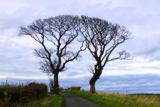 Kissing TreesBroadleaf Tree Pair · 1589 ydKissing TreesBroadleaf Tree Pair · 1592 yd
 Binnend VillageRuins · 1739 yd
 Craigencalt MillVisitor information · 1.5 mi
 Burntisland, Kinghorn Road, Burntisland Cemetery with Lodge and Hearse HouseCemetery (19th Century), Hearse House (19th Century), Lodge (19th Century) · 1.5 mi
 The Ecology CentreHeritage attraction · 1.6 mi
 Burntisland BeachBeach / strand · 1.7 mi
More archaeology and monuments in Fife · All of Fife
What do you know about this place?