
What is recorded here
Stone Structure by a Loch is a standing or carved stone in Na h-Eileanan Siar, Scotland.
From the Geograph Britain and Ireland public picture record picture record
Places near here
Photo credits
- Sandy Gerrard, Wikimedia Commons · CC BY-SA 2.0
- Gerald Ponting, Wikimedia Commons · CC BY-SA 2.0
- David Dixon, Wikimedia Commons · CC BY-SA 2.0
- David Bremner, Wikimedia Commons · CC BY-SA 2.0
- Eileen Henderson, Wikimedia Commons · CC BY-SA 2.0
- Tom Richardson, Wikimedia Commons · CC BY-SA 2.0
- JJM, Wikimedia Commons · CC BY-SA 2.0
- Chmee2, Wikimedia Commons · CC BY-SA 3.0
- Bob Embleton, Wikimedia Commons · CC BY-SA 2.0
- Colin Smith, Wikimedia Commons · CC BY-SA 2.0
 BreascleteCommunity Centre (modern), School · 1.5 mi
 Breascleit CairnAncient tomb or cairn · 1.5 mi
 Lewis, BreascleteGrain Mill (19th Century) · 1.5 mi
 Lewis, StonefieldStanding Stone (prehistoric) · 1.6 mi
_War_Memorial_-_geograph.org.uk_-_7765514.jpg/250px-East_Loch_Roag_(Callanish,_Garynahine_and_Breasclete)_War_Memorial_-_geograph.org.uk_-_7765514.jpg "Photo: David Bremner, Wikimedia Commons · CC BY-SA 2.0") East Loch Roag War MemorialMemorial · 1.7 mi
East Loch Roag War MemorialMemorial · 1.7 mi Callanish CemeteryChurch, cross or graveyard · 1.9 mi
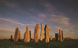 Tursachan ChalanaisHeritage attraction · 2.3 mi
 Forestry BridgeHeritage place · 2.3 mi
.JPG/250px-Callanish_Stones_in_summer_2012_(7).JPG "Photo: Chmee2, Wikimedia Commons · CC BY-SA 3.0") LeòdhasIsland · 2.4 mi
LeòdhasIsland · 2.4 mi Bratanais MòrIsland · 2.6 mi
 Stream and Beach Loch MhicLeodBeach · 2.9 mi
 Port a' ChaoilHeadland · 3.0 mi
More archaeology and monuments in Na h-Eileanan Siar · All of Na h-Eileanan Siar
What do you know about this place?