
What is recorded here
From the National Monuments Service (Archaeological Survey of Ireland) record DG098-015001
Places near here
Picture notes
- National Inventory of Architectural Heritage
- Computer-made picture. It does not show this monument.
- Kenneth Allen, Wikimedia Commons · CC BY-SA 2.0
- Computer-made picture. It does not show this mountain top.
- EecherplazGinkgo06.jpg : Cayambe derivative work: Ginkgotree ( talk ), Wikimedia Commons · CC BY-SA 3.0
- Ronnie Nijboer, Wikimedia Commons · CC0
- David Dixon, Wikimedia Commons · CC BY-SA 2.0
- louise price, Geograph · CC BY-SA 2.0
- louise price, Wikimedia Commons · CC BY-SA 2.0
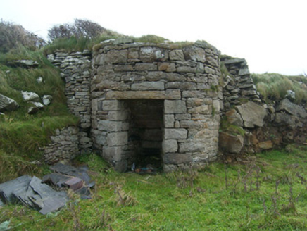 kiln431 yd
Explorer Tom Kiln in Rahan Near is a round lime kiln from the 1800s that really knows how to bake. Most are square, but this one chose to be cool and circular. Stick your head out the window and give it a cheeky salute!
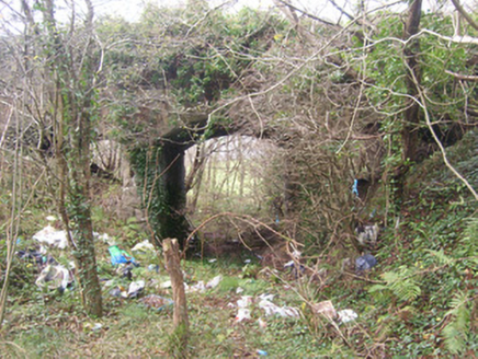 bridge435 yd
Explorer Tom Bridge in Killaghtee once carried the road over the narrow gauge railway to Killybegs. Three concrete arches wear sandstone above them; I picture each one holding its breath as a train tootled through. The line closed in 1960.
 Cross-slab in Beaugreen GlebeCross-slab · 485 ydComputer-made picture
Explorer Tom Cross-slab in Beaugreen Glebe is a cheeky little puzzle piece, hiding a triquetra right next to its Maltese cross. It’s been standing guard over this graveyard since the old church stopped being used in 1826. That D-shaped notch on the arm? I’d bet it was a carpenter’s error they just decided to leave be.
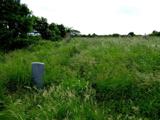 Killaghtee Old Church GraveyardGraveyard · 489 yd
Explorer Tom Killaghtee Old Church Graveyard sits beside the old church; inside the graveyard, southwest of that church, the survey records a cross-inscribed slab. The Civil Survey called the church 'in reparation', and it remained in use until 1826. I like how one small mapped area holds separate records for the graveyard, church and stone.
 Bullaun stone in Beaugreen GlebeBullaun stone · 493 ydComputer-made picture
Explorer Tom Bullaun stone in Beaugreen Glebe is playing a game of musical chairs with the archaeologists! A man named Conaghan saw two broken ones back in 1977, but now they’re just... gone? I think they might have rolled off into the sea and are currently swimming laps.
 Sentry HillMountain / peak · 1173 ydComputer-made picture
Explorer Tom Sentry Hill in County Donegal sounds like it’s been watching the horizon for centuries, keeping an eye out for anything suspicious. It’s the sort of quiet peak that feels like it knows all your secrets but is too polite to ask.
 Ginkgo1331 yd
Explorer Tom Ginkgo in County Donegal is basically a dinosaur wearing a leafy coat, surviving things that would kill other trees instantly. It’s exotic, weird, and definitely not what you’d expect to find in Donegal. Pack a picnic and an excuse for why you’re talking to a tree so loudly.
 Wych Elm1.0 mi
Explorer Tom Wych Elm four in County Donegal is just standing there looking confused about why you need permission to see a tree. It's probably thinking about the past. Ask it if it remembers when elms were cool again.
 Carnlullagh HillMountain / peak · 1.8 miComputer-made picture
Explorer Tom Carnlullagh Hill is listed simply as a mountain or peak, which feels like a very lazy introduction. I suspect it has been patiently waiting for someone to actually notice its specific personality rather than filing it under 'generic hill'.
 Rashenny PointHeadland · 2.5 mi
Explorer Tom Rashenny Point thinks its secret talent is competitive napping, and honestly? It’s good at it. The headland is just vibing out there in the sun. Take the long way round, because this spot deserves the extra effort and scenic drive.
 Carntullagh HeadHeadland · 2.6 mi
Explorer Tom Carntullagh Head is a rugged County Donegal point that apparently doubles as a fish farm. I imagine the wild seabirds looking down at their new plastic neighbours with mild confusion, wondering if this is still the natural order of things.
 Rotten IslandIslet · 2.6 mi
Explorer Tom Rotten Island sounds like a pirate's insult, but its lighthouse story is serious. The light guides boats into Killybegs Harbour; three workers drowned returning from the island while it was being built. I would remember them whenever that white tower comes into view.
More archaeology and monuments in County Donegal · All of County Donegal

What do you know about this place?Tap to add a comment or ask a question