
What is recorded here
Located on a NW-facing slope in rough heather- and sedge-covered upland terrain, overlooked at NE by Contycro hill, with a small lake/bog pool 20m to W and a larger lake 200m to E. This standing stone is not indicated on any edition of the OS 6-inch maps. Upright, flat-topped, roughly rectangular-shaped slab (H 0.61m;…
Read the whole record
From the National Monuments Service (Archaeological Survey of Ireland) record DG090-016
Places near here
Photo credits
- National Inventory of Architectural Heritage
- Maker not stated on source page, www.dreamstime.com
- Maker not stated on source page, www.irelandhighlights.com
- Maker not stated on source page, www.pinterest.com
- Maker not stated on source page, www.visitgalway.ie
- John M, Geograph · CC BY-SA 2.0
- Maker not stated on source page, www.tripadvisor.com.au
- Maker not stated on source page, commons.wikimedia.org
- Donegal Daily (publisher); individual photographer not stated, www.donegaldaily.com
- Einaz80, Wikimedia Commons · CC BY-SA 4.0
- Maker not stated on source page, www.deezer.com
 kiln869 yd
Explorer Tom Kiln in An Caiseal would probably spend its lotto win buying a really nice hat to go with its tapering stone shape. It…
 Standing stone in An Gaineamh Agus An CurraoinStanding stone · 1116 yd
Explorer Tom Standing stone in An Gaineamh Agus An Curraoin is a skinny little sentinel perched on a rocky hill with a panoramic…
 Fairy fort / earthen ringfort in An Bhráid ÍochtarachFairy fort / earthen ringfort · 1464 yd
Explorer Tom Fairy fort / earthen ringfort in An Bhráid Íochtarach sits on a ridge with a commanding view of Glencolumbkille. It’s…
 Bullaun stone in Cill GhabhlaighBullaun stone · 1736 yd
Explorer Tom Bullaun stone in Cill Ghabhlaigh is a tiny, rocky bathtub! It sits right by the Murlin River and fills up with rain. I…
 Cointe Cró Court TombCourt tomb · 1.0 mi
Explorer Tom Cointe Cró Court Tomb was literally buried under a marsh until the land was drained in 2011. Now it’s just a few stones…
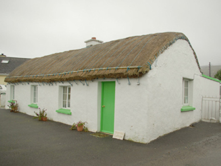 Teachín TessieHouse · 1.3 mi
Explorer Tom Teachín Tessie has a rounded thatched roof that looks like it’s just dozing off in the Glencolumbkille wind. Built…
 Biddy's PubPub · 1.3 mi
Explorer Tom Biddy's Pub sits at the crossroads in Glencolumcille, where the music stops and the shouting starts. It claims to be…
 Cafe BlastaCafé · 1.4 mi
Explorer Tom Cafe Blasta in County Donegal took approximately four hundred cups of tea to build its walls, meaning every sip you…
 Mapped cemeteryCemetery · 1.4 mi
Explorer Tom Mapped cemetery ended up in the wrong place because a cart driver got drunk on whiskey and took a left turn when he…
 Páirc na nGael, Naomh ColumbaGAA ground · 1.7 mi
 Glencolmcille Folk VillageMuseum · 1.9 mi
Explorer Tom Glencolmcille Folk Village looks like a handful of Donegal cottages stopped for a chat above the sea and forgot to go…
 An Trá Bheag (Trá Bheag an Ghleanna)Beach / strand · 2.1 mi
Explorer Tom An Trá Bheag means the small beach, and this curve of sand by Gleann Cholm Cille lives up to the name. The Folk…
More archaeology and monuments in County Donegal · All of County Donegal

What do you know about this place?Tap to add a comment or ask a question