What is recorded here
Marked on the 1839 and 1941 eds of the OS 6-inch map, and described as ‘St. Bridget’s Well’ on both. It is located in a little quarry towards the bottom of a gentle S-facing slope. The well is an oval feature (dims 1.3m x 0.9m) defined by moss-covered stones, but with very little water. The well is still venerated, and blue crosses are painted onto stones in the vicinity. There is a shrine with a single statue of a female saint attached to a nearby tree. The church (WX037-005001-) is c. 120m to the NNE and the tower house (WX037-007----) is c. 50m to the S.
Marked on the 1839 and 1941 eds of the OS 6-inch map, and described as ‘St. Bridget’s Well’ on both. It is located in a little quarry towards the bottom of a gentle S-facing slope. The well is an oval feature (dims 1.3m x 0.9m) defined by moss-covered stones, but with very little water. The well is still venerated, and blue crosses are painted onto stones in the vicinity. There is a shrine with a single statue of…
From the National Monuments Service (Archaeological Survey of Ireland) record WX037-006
The monument record does not grant public access. Check the route and ask the landowner before entering private land.
- What survives
- Recorded monument
Places near here
Photo credits
- Mike Searle, Wikimedia Commons · CC BY-SA 2.0
- National Inventory of Architectural Heritage
- David Hawgood, Wikimedia Commons · CC BY-SA 2.0
- Thommcg1980, Wikimedia Commons · CC BY-SA 4.0
- AFBorchert, Wikimedia Commons · CC BY-SA 4.0
- Danielclauzier, Wikimedia Commons · CC BY-SA 3.0
- Maker named on the Wikimedia Commons picture page · CC BY-SA 3.0
- Chris, Wikimedia Commons · CC BY-SA 2.0
- Sarah777 at English Wikipedia, Wikimedia Commons · Public domain
- Richard Webb, Geograph · CC BY-SA 2.0
_-_geograph.org.uk_-_4570708.jpg/250px-Castles_of_Leinster,_Artramon,_Wexford_(2)_-_geograph.org.uk_-_4570708.jpg "Photo: Mike Searle, Wikimedia Commons · CC BY-SA 2.0") Artramon CastleCastle, tower house · 57 ydEcclesiastical enclosure in ArtramonEcclesiastical enclosure · 125 yd
Artramon CastleCastle, tower house · 57 ydEcclesiastical enclosure in ArtramonEcclesiastical enclosure · 125 yd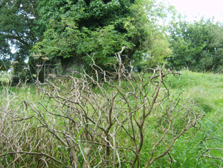 graveyard/cemetery132 yd
 Artramon HouseCountry house · 436 yd
 Passage TowerCastle, tower house · 2.2 mi
 Commodore John Barry MemorialMemorial · 2.9 mi
 Siege of WexfordSiege · 3.2 mi
 Sack of WexfordSiege · 3.2 mi
 Dawn Redwood3.8 mi
 Raven Point Nature ReserveForest · 4.8 mi
 Curracloe BeachBeach / strand · 5.0 mi
 Forth MountainMountain / peak · 5.5 mi
More archaeology and monuments in County Wexford · All of County Wexford
What do you know about this place?