What is recorded here
From OpenStreetMap (© OpenStreetMap contributors) n12276936269
Places near here
Picture notes
- Paul McIlroy, Geograph · CC BY-SA 2.0
- Donald MacDonald, Wikimedia Commons · CC BY-SA 2.0
- Colin Park, Geograph · CC BY-SA 2.0
- Copernicus Sentinel-2, ESA, Wikimedia Commons · CC BY-SA 3.0 igo
- Computer-made picture. It does not show this playground.
- Anne Burgess, Wikimedia Commons · CC BY-SA 2.0
- Eric Jones, Geograph · CC BY-SA 2.0
- Rossographer, Geograph · CC BY-SA 2.0
- S. M'S., Wikimedia Commons · Public domain
- Chris Burrell, Wikimedia Commons · Creative Commons Attribution-ShareAlike 2.0
- Yvonne Wakefield, Geograph · CC BY-SA 2.0
- David Smith, Geograph · CC BY-SA 2.0
 SroanderrigHeadland · 1047 yd
Explorer Tom Sroanderrig Point offers views towards Rathlin and Fair Head, connecting this headland to other dramatic features along the coast.
 Rathlin West LighthouseLighthouse · 1168 yd
Explorer Tom Rathlin West Lighthouse stands firm in County Antrim, likely keeping a steady watch over the waves for anyone passing by safely.
 Derginan PointHeadland · 1449 yd
Explorer Tom Derginan Point is a rugged headland, best admired from the West Lighthouse nearby where the sea roars wildly.
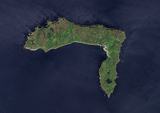 Rathlin IslandIsland · 1.9 mi
Explorer Tom Rathlin Island captures true color from space, showing off its rugged charm in County Antrim waters.
 Children's playground3.3 miComputer-made picture. It does not show this playground.
Explorer Tom This unnamed area in County Antrim is likely where local children gather to burn off energy and have fun together.
 Boat House3.3 mi
Explorer Tom Boat House in Boat House The Station Rathlin Island is a unique Grade B1 find. This charming structure has likely hosted many boats and stories over the years.
 Ballycarry Trail, RathlinWalking route · 3.9 mi
Explorer Tom Curious about Rathlin’s Ballycarry Trail? With new dwellings popping up nearby, it feels like a place constantly waking up.
 Carrickarede IslandIslet · 4.2 mi
Explorer Tom Carrickarede Island once had a salmon fishery. Now it’s just a quiet, disused spot.
_(page_1_crop).jpg/250px-Bruce's_Castle-_Island_of_Raghery,_1833_(IA_jstor-30003195)_(page_1_crop).jpg "Photo: S. M'S., Wikimedia Commons · Public domain") Rathlin CastleRuins · 4.2 mi
Rathlin CastleRuins · 4.2 miExplorer Tom Rathlin Castle sits in County Antrim, a rugged ruin where old stories from the Dublin Penny Journal still linger in the air.
 Fortification: bruce's castle in BallycarryFortification: Bruce's Castle · 4.2 mi
Explorer Tom Bruce's Castle stands as a medieval fortress in Ballycarry, with echoes of Robert the Bruce still lingering on these historic grounds.
 Sheep IslandIslet · 4.2 mi
Explorer Tom Sheep Island floats peacefully near Ballintoy Harbour, probably dreaming of woolly flocks and quiet tides.
 Lime Kiln, Carrick-a-redeMonument · 4.6 mi
Explorer Tom The Lime Kiln at Carrick-a-rede processed limestone directly from the hills in County Antrim, a handy industrial spot for local builders.
More cliffs, bays and coast in County Antrim · All of County Antrim

What do you know about this place?Tap to add a comment or ask a question