Places near here
Photo credits
- Kokai, Wikimedia Commons · CC BY-SA 2.0
- Burgess Von Thunen, Wikimedia Commons · CC BY-SA 2.0
- Dave Dunford, Wikimedia Commons · CC BY-SA 2.0
- Les Hull, Wikimedia Commons · CC BY-SA 2.0
- Stephen McKay, Wikimedia Commons · CC BY-SA 2.0
- Philip Jeffrey, Wikimedia Commons · CC BY-SA 2.0
- David Howard, Wikimedia Commons · CC BY-SA 2.0
- Jo, Wikimedia Commons · CC BY-SA 2.0
 Round Oak PlantationForest · 342 yd
 Harlestone FirsForest · 1200 yd
 Ironstone cottage, Upper HarlestoneOld home or work place · 1690 yd
 Hopping Hill GardensMountain or hill · 1.1 mi
 Stables of Harlestone House.Listed building · 1.1 mi
 Nobottle Water TowerCastle, fort or tower · 1.4 mi
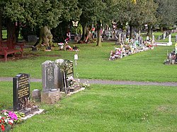 Dallington CemeteryChurch, cross or graveyard · 1.4 mi
 St Michael'sCemetery · 1.9 mi
 DustonVisitor information · 1.9 mi
 Dallington ParkPark · 1.9 mi
 Sixfields StadiumStadium · 2.2 mi
 The lift tower at St James, NorthamptonCastle, fort or tower · 2.2 mi
More woods, forests and old trees in West Northamptonshire · All of West Northamptonshire

What do you know about this place?Tap to add a comment or ask a question