What is recorded here
Castle Quan rose on a boggy terrace above the River Coon gorge until men destroyed it around 1830 to build Coon chapel. Its greenstone cellars still hold beneath the earth while the raised bawn marks the lost walls. The castle gave up its bones so the chapel could stand, turning a fortified home into church material.
On a broad rather boggy, though partly reclaimed, terrace just above the gorge of the River Coon. There are good views N and S along the Coon and down to the Dinin river valley, also E and W across the Coon valley to the low rolling hills beyond. An RC church and graveyard are located immediately E of the SE quadrant of the bawn (KK011-006002-). According to the OS letters (1839) (O'Flanagan 1930, vol. 1, 21) in this townland, 'they shew the foundation of an old castle, in the centre of a piece of ground forty five yards square [c. 41m], surrounded by a trench eight feet [2.4m] deep and twelve 3.6m] in breadth. This castle, according to tradition, was called Caislen Churain Fheidhlim Ui Neill, i.e., the Castle of the Whelps of Feilim O'Neill, and stood to a considerable height till about twelve years ago'. Carrigan (1905, vol. 3, 457) states that, 'The castle of Coon stood till about 1830, when it was thrown down to provide materials for the building of Coon chapel. It was a strong castle, built of greenstone and grouting. its cellars remain uninjured, but nothing now marks its site but a square enclosure, 50 or 60 yds. across and surrounded by a deep fosse. In Irish it is called Cushlawn-aChooing (Caislean a'Chuain), i.e. the Castle of Coon. It appears in a document of 1790 as Castlecoonfeily'. The castle is not visible at ground level, however, the enclosing bawn survives as a raised platform.
Compiled by: Jean Farrelly
Date of upload: 19 December 2016
Built by the de Quen family in the 12th century, Castle Quan was strategically positioned to control key river crossings and trade routes in the region. It is remembered for its role in local medieval defense and as a symbol of feudal power in the area.
The monument record does not grant public access. Check the route and ask the landowner before entering private land.
- What survives
- Recorded monument
Places near here
 IndicatedBawn · 5 yd
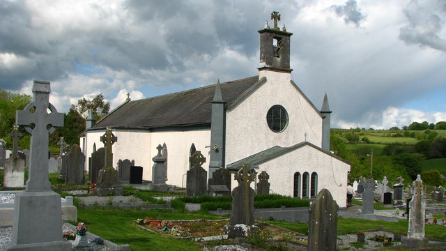 Saint Brigid's Catholic Churchchurch/chapel · 65 yd
 Burn's Bridgebridge · 233 yd
 Uskerty WoodForest · 1.5 mi
 Glenmullen WoodWood · 2.7 mi
 Church (Site of) Graveyard St. LongorysChurch · 2.9 mi
 Grave YardGraveyard · 2.9 mi
 Clogharinka Castle (in ruins)Castle, unclassified · 2.9 mi
 Kilgorey Old BurialVisitor information · 3.1 mi
 Gallows HillMountain / peak · 3.2 mi
 Footprints In CoalMuseum · 3.7 mi
 Estate YardMemorial · 3.7 mi