
What is recorded here
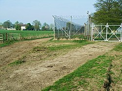
Shifford Lock Cut Bridge is a historic building in West Oxfordshire, England.
From the Geograph Britain and Ireland public picture record picture record
Places near here
Photo credits
- Philip Jeffrey, Wikimedia Commons · CC BY-SA 2.0
- David Purchase, Wikimedia Commons · CC BY-SA 2.0
- Steve Newman, Wikimedia Commons · CC BY-SA 2.0
- Tim Kirby, Wikimedia Commons · CC BY-SA 2.0
- Roger Templeman, Wikimedia Commons · CC BY-SA 2.0
- Bill Nicholls, Wikimedia Commons · CC BY-SA 2.0
- Philip Halling, Wikimedia Commons · CC BY-SA 2.0
- David Smith, Wikimedia Commons · CC BY-SA 2.0
- David Luther Thomas, Wikimedia Commons · CC BY-SA 2.0
- David Hawgood, Wikimedia Commons · CC BY-SA 2.0
 Thames PathVisitor information · 24 yd
 Chimney MeadowsNature reserve · 656 yd
_-_geograph.org.uk_-_100967.jpg/250px-Shifford_Chapel_(December_2005)_-_geograph.org.uk_-_100967.jpg "Photo: Steve Newman, Wikimedia Commons · CC BY-SA 2.0") Shifford Chapel (December 2005)Church, cross or graveyard · 1170 yd
Shifford Chapel (December 2005)Church, cross or graveyard · 1170 yd Shifford ChapelChurch, cross or graveyard · 1313 yd
 Harrowdown HillMountain / peak · 1.4 mi
 Boundary stone beside A420 near BucklandMonument or public art · 2.0 mi
 Stone or sculpturePublic sculpture · 2.2 mi
 New BridgeScheduled monument · 2.3 mi
 Nursery PlantationWood · 2.5 mi
 Island in former gravel pitIsland · 3.1 mi
 Linch Hill Vineyard, Stanton HarcourtMountain or hill · 3.2 mi
 R.A.F. Bampton CastleCastle, fort or tower · 3.4 mi
More historic places in West Oxfordshire · All of West Oxfordshire
What do you know about this place?