What is recorded here
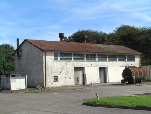
Detached multiple-bay double-height outbuilding, built c. 1955. Pitched corrugated-iron roof with circular-profile cast-iron flues to roof ridge. Cast-iron rainwater goods and timber eaves. Roughcast rendered walls. Square-profile metal vent pipes to rear. Rendered walls. Square-headed opening with strip window having steel-framed swivelling and fixed windows with continuous concrete sill. Square-headed door openings with accordion folding steel double doors. Single-bay single-storey building to north having flat roof with oversailing eaves, roughcast rendered walls, concrete pilotis to front (west) elevation, full-width tripartite steel-framed windows with overlights to front elevation, steel-framed windows with overlights to west end of north and south elevations, and half-glazed steel door to south elevation. Multiple-bay single-storey building to west having flat roof with oversailing eaves, cast-iron rainwater goods, rendered walls, and square-headed openings with steel-framed windows and timber battened doors. Rectangular-plan weighbridge to site having cast-iron frame and plate with maker's marks in relief to frame, with concrete kerbs to east and west sides.
Part of large coherently planned group of hospital structures, built as Tuberculosis Sanatorium under Doctor Noel Browne as Minister for Health. Forms interesting group with nearby weighbridge and chimney, evidence of sanatorium's original working farm. Visible from road, notable roofline adds architectural interest.
This does not grant access. Most recorded buildings are privately owned; view them only from public ground unless the owner allows entry.
Places near here
 Saint Stephen's Hospitalhospital/infirmary · 315 yd
 Sarsfields Court (in Ruins)Castle, unclassified · 408 yd
 Pit-burial in KillydonoghoePit-burial · 823 yd
 Silverspring Starch WorksMill, cloth · 898 yd
 Site of Grave YardBurial ground · 997 yd
 Glanmire Heritage SocietyMemorial · 2.0 mi
 Old Court (Site of)Castle, unclassified · 2.1 mi
 Carberrytown WoodWood · 2.5 mi
 Cork WalksVisitor information · 4.6 mi
 Lavitts QuayMemorial · 4.9 mi
 Mount Hillary - Knightfield LoopWalking route · 22 mi
 St Fursey's WellSpring · 24 mi
Other information
Photo: National Inventory of Architectural Heritage · Website use allowed for educational or private purposes with source credit