
Places near here
Photo credits
- Brian Clift, Wikimedia Commons · CC BY-SA 2.0
- Alan Atkins, Wikimedia Commons · CC BY-SA 2.0
- Peter Evans, Wikimedia Commons · CC BY-SA 2.0
- Stephen McKay, Wikimedia Commons · CC BY-SA 2.0
- Noisar, Wikimedia Commons · CC BY-SA 2.0
- Gordon Griffiths, Wikimedia Commons · CC BY-SA 2.0
- Jonathan Wilkins, Wikimedia Commons · CC BY-SA 2.0
- Brian Clift , Tony Hisgett . Derivative work by LivingInMediocrity ., Wikimedia Commons · CC BY-SA 2.0
- Andy Mabbett, Wikimedia Commons · CC BY-SA 4.0
 Turners HillMountain / peak · 571 yd
 Darbys HillMountain / peak · 750 yd
 South Portal, Netherton Tunnel, Warrens Hill Park Birmingham Canal Netherton Tunnel Branch Windmill End, Rowley KingsListed building · 983 yd
 Bullfield BridgeCanal bridge · 1014 yd
 Cobb's Engine HouseHeritage attraction · 1015 yd
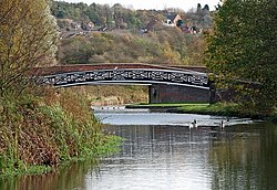 Bumble Hole Nature Reserve Black Country GeositeNature reserve · 1151 yd
 Statue of Joseph Darby, NethertonMonument or public art · 1.2 mi
 Standing StoneAncient stone or rock art · 1.3 mi
 Brades LocksVisitor information · 1.4 mi
 Dudley Time TrailWalking route · 1.5 miDudley Geological Heritage TrailWalking route · 1.5 mi
 Blackheath Central Methodist Chapel War MemorialMemorial · 1.6 mi
More mountains and hills in Sandwell · All of Sandwell

What do you know about this place?Tap to add a comment or ask a question