About this business
From OpenStreetMap (© OpenStreetMap contributors) way 961102797
Places near here
Picture notes
- Kenneth Allen, Geograph · Creative Commons Attribution-ShareAlike 2.0
- National Inventory of Architectural Heritage
- John M, Geograph · CC BY-SA 2.0
- Computer-made picture. It does not show this playground.
- Pearse MacIntyre, Wikimedia Commons · CC BY-SA 4.0
- National Library of Ireland on The Commons, Wikimedia Commons · No restrictions
- MarieDub, Wikimedia Commons · CC BY-SA 4.0
- Einaz80, Wikimedia Commons · CC BY-SA 4.0
- Ardfern, Wikimedia Commons · CC BY-SA 3.0
- Ben Brooksbank, Geograph · CC BY-SA 2.0
- Kenneth Allen, Geograph · CC BY-SA 2.0
- Michael Earnshaw, Geograph · CC BY-SA 2.0
 Teach Pobail Naomh ColumbaChurch/chapel · 95 yd
Explorer Tom Teach Pobail Naomh Columba’s Celtic cross finials mark this church, but the private ownership means we must admire it from public ground only.
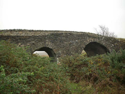 Droichead an tSráidBridge · 255 yd
Explorer Tom Droichead an tSráid crosses the Murlin River on two unequal stone arches, with a pointed cutwater between them. One corner has later repairs. It is a lopsided smile of a bridge, but that middle stone nose still looks ready to part the river.
 Biddy's PubPub · 260 yd
Explorer Tom Biddy's Pub in County Donegal is where the music stops and the shouting starts. Order a pint, look confused, and pretend you know the local dialect perfectly.
 Children's playground292 ydComputer-made picture. It does not show this playground.
Explorer Tom I wonder if this modern Children's playground in County Donegal features a climbing frame shaped like a giant whale.
 Cross-inscribed pillar in An Caiseal (tc Málainn Bhig)Cross-inscribed pillar · 435 yd
Explorer Tom Surrounded by a cairn in Glencolumbkille's rocky valley floor, this cross-inscribed pillar displays a stem connecting quartered-circle and roundel motifs on its NE face.
.jpg/250px-Pillar_cross_at_Glencolmcille_aka_Glencolumbkille_in_Donegal_(8735027634).jpg "Photo: National Library of Ireland on The Commons, Wikimedia Commons · No restrictions") Cross-inscribed pillar in An TsráidCross-inscribed pillar · 452 yd
Cross-inscribed pillar in An TsráidCross-inscribed pillar · 452 ydExplorer Tom Cross-inscribed pillar in An Tsráid has loops on its face that look like handles for carrying it around. I wonder if someone tried to lift this slab and got tangled up in its own patterns.
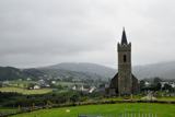 Glencolmcille Old GraveyardGraveyard · 505 yd
Explorer Tom Glencolmcille Old Graveyard holds two church stories: the modern church stands just north of an older church site, whose building was pulled down in 1828. I spotted a useful caution in the record too: earlier writers mentioned a circular enclosure, but the later survey saw no trace. One dot, several layers, and not all equally certain.
 Glencolmcille Folk VillageMuseum · 920 yd
Explorer Tom Glencolmcille Folk Village lines up Donegal homes from the 18th, 19th and 20th centuries in replica cottages. I could walk from one period to another before my tea went cold, though the furniture would change on me at every door. It is a clever way to compare ordinary lives.
 Rossan PointHeadland · 2.7 mi
Explorer Tom Rossan Point provides a vantage point near Malin Beg, perfect for watching the waves crash and the seagulls dance.
 Malin Beg HostelHostel · 3.5 mi
Explorer Tom Malin Beg Hostel sounds like a place where backpackers trade stories that sound more like horror films. Ask about the strangest guest they’ve ever had.
 Silver Strand ViewpointViewpoint · 3.6 mi
Explorer Tom Silver Strand Viewpoint looks south-west, capturing the shimmering waters and rugged coastline in a truly scenic Donegal landscape.
 Slieve League se TopMountain / peak · 4.3 mi
Explorer Tom Slieve League SE Top is recorded as a mountain / peak in County Donegal, featuring an almost flat summit area. It leads to the narrow arete known as One Man's Pass, so keep your footing steady and your nerves calm.

What do you know about this place?Tap to add a comment or ask a question