
Places near here
Photo credits
- Albert Bridge, Geograph · CC BY-SA 2.0
- Eric Jones, Wikimedia Commons · CC BY-SA 2.0
- N Chadwick, Geograph · CC BY-SA 2.0
- Elkay62, Wikimedia Commons · CC BY-SA 4.0
- Eric Jones, Geograph · CC BY-SA 2.0
- Albert Bridge, Wikimedia Commons · CC BY-SA 2.0
- Dennis Reynolds, Geograph · CC BY-SA 2.0
- Rossographer, Geograph · CC BY-SA 2.0
- User:SeamusSweeney, Wikimedia Commons · CC BY-SA 3.0
- David Smith, Wikimedia Commons · CC BY-SA 2.0
- Nigel Thompson, Geograph · CC BY-SA 2.0
 Rough IslandIslet · 1.1 mi
Explorer Tom Rough Island’s family tree is mostly made up, with generations of ancestors who were definitely real but also definitely not. It sits there with a causeway that looks like it was drawn by a toddler with a crayon. Stand there long enough and someone will ask if you're lost.
 Alexandra HouseHouse · 1.3 mi
Explorer Tom Alexandra House in Castleaverry is a Grade B1 beauty from the early 1900s that probably hosts the best tea parties in County Down. I’m pretty sure it’s hiding a secret recipe for shortbread right under the floorboards. Bring biscuits, every good story needs biscuits.
 Scrabo HillMountain / peak · 1.7 mi
Explorer Tom Scrabo Hill in County Down is currently being judged by the local sheep, who think its tower looks ridiculous for something that can’t even fly. They’ve decided to stand very close to the base and stare up at it with intense disapproval, which is a lot of work for animals. Bring the dog, it'll have opinions.
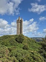 Scrabo TowerHeritage attraction · 1.7 mi
Explorer Tom I saw Scrabo from miles away and pretended I meant to find it. Scrabo Tower rises above Newtownards like a 41 metre stone exclamation mark, visible long before you reach the hill. It was built to commemorate Charles Vane, the third Marquess of Londonderry, which explains its original name, the Londonderry Monument, despite the city being far away. The tower also sits on the site of a prehistoric hill fort, so it was hardly the first occupant to notice the commanding position. Vane himself had changed his surname from Stewart after marrying a rich heiress, a small detail for anyone who thinks grand families never rebrand. If I built a tower for every important person, somebody would ask where I found the stone. The surrounding hill is a public walking destination with wide views; access inside the tower can vary, so check current opening before counting on the stairs. Even from outside, the stonework and sweep over Strangford Lough are worth the climb. Scrabo knew how to be seen before the tower arrived.
 Tower in ScraboTower · 1.7 mi
Explorer Tom Tower in Scrabo was built by tenantry to make sure everyone remembered Charles William Vane forever, which is a lot of pressure for a building. It probably orders extra vinegar with its chips. Whisper a secret at it, it's kept worse.
_-_geograph.org.uk_-_4723607.jpg/250px-Walled_garden,_Killynether,_Newtownards_-_October_2015(1)_-_geograph.org.uk_-_4723607.jpg "Photo: Albert Bridge, Wikimedia Commons · CC BY-SA 2.0") Walled GardenGarden · 1.7 mi
Walled GardenGarden · 1.7 miExplorer Tom Walled Garden in County Down has strong opinions on modern buildings, specifically that they’re too tall and not enough brick. The walls feel like they’re whispering gossip about everyone who’s ever walked past without appreciating the structural integrity of the past. If it rains, blame me.
 Newtownards priory: church of dominican friary in Corporation North (newtownards)Newtownards Priory: Church of Dominican Friary · 2.0 mi
Explorer Tom Newtownards priory: church of dominican friary is sitting there judging the place that replaced it with modern concrete and bad taste. It would say something scathing if it had lips. Bring a flask of something warm and a story to swap with the ghosts.
 Blair Mayne statueMonument · 2.2 mi
Explorer Tom Blair Mayne statue in County Down is standing there looking like he’s about to catch a bus that hasn’t come in years. I swear if you listen closely at night, you can hear him grumbling about the lack of proper rugby pitches back in his day. He’s got a permanent scowl that makes my own face hurt just looking at it. Bring a pen pal, they'll be jealous.
 Castle Espie Wetland CentreNature reserve · 2.2 mi
Explorer Tom Castle Espie Wetland Centre in County Down is feuding with the next village over who stole its best heron. The ducks are taking sides, and the mud is getting very political. A handy spot to stretch your legs and your imagination.
 Kiltonga Nature ReserveNature reserve · 2.7 mi
Explorer Tom Kiltonga Nature Reserve would describe the 1800s to a teenager by saying it was all very dramatic, with everyone wearing itchy wool and having strong opinions about nothing in particular. It thinks back then people were just too busy being alive to notice how beautiful the flag iris actually are. Hum something sad nearby, it adds atmosphere.
 Tir n'an OgCemetery · 3.5 mi
Explorer Tom Tir n'an Og Cemetery in County Down thinks Dublin tourists are all noise and no taste, especially when they take selfies with gravestones. It prefers the quiet company of the wind and some moss. Sit on a wall near it and pretend you're in a painting.
 Lake Walk, Mount StewartWalking route · 3.5 mi
Explorer Tom Lake Walk at Mount Stewart had a matchmaker working there who paired off half the village, but I think she mostly just liked the view over the water. It’s one of those spots where the gardens are so fancy they make you feel like you need to iron your t-shirt before walking past. Look serious, nod slowly, you're basically an expert now.
More archaeology and monuments in County Down · All of County Down

What do you know about this place?Tap to add a comment or ask a question