What is recorded here
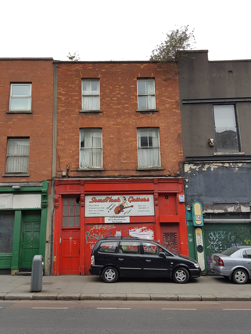
Attached two-bay three-storey house over basement, built c. 1730, refaced c. 1890 and shopfront inserted to ground floor. Flat roof hidden behind red brick parapet with concrete coping. Rendered chimneystack to north party wall with clay pots. Machine-made red brick, laid in Flemish bond, to front (east) elevation, and rendered walling to rear. Square-headed window openings having granite sills, replacement two-over-two pane timber sliding sash windows to front, replacement uPVC windows visible to rear. Edwardian timber shopfront, comprising incised timber pilasters supporting acanthus leaf brackets with plain brackets over, surmounted by tripartite timber fascia and carved timber cornice. Square-headed shop door opening to south end of shopfront, having nine-pane overlight. Recent glazed timber door to north end, overlight now boarded up. Recent display window with metal roller shutter. Granite kerbing to footpath to front.
The original cruciform Dutch-Billy roof and top floor of this building were removed in the mid-twentieth century. Despite this, the building retains much of its historic character, making a positive contribution to the streetscape. It retains a significant amount of early Georgian fabric, including corner fireplaces, and relates to the landmark development and evolution of the Aungier Estate, and the increasingly rare Dutch Billy typology. Historic maps show that the original return was located off of the stairwell rather than the reception rooms, indicating that it was a later Dutch Billy typology. The return was demolished and realigned to the north in the nineteenth century. Although a later feature, the shopfront is a cohesive and largely intact example of an Edwardian commercial frontage, with expertly carved console brackets and timber cornicing, united in a thorough design. Aungier Street was laid out over the ruins of the medieval Whitefriars monastery in 1661 by Francis Aungier, on foot of the Restoration of King Charles II. The development constituted the first planned development or suburb in Dublin. The first houses were built quickly around 1664-5, with a second wave of development in the second quarter of the eighteenth century when No. 73 was constructed.
This does not grant access. Most recorded buildings are privately owned; view them only from public ground unless the owner allows entry.
Places near here
 Thomas MooreMemorial · 45 yd
 The Snughouse · 66 yd
 Whitefriar Grillhouse · 71 yd
 Gatehouse in Unknown TownlandGatehouse · 97 yd
 Ecclesiastical enclosure in Unknown TownlandEcclesiastical enclosure · 99 yd
 Special Olympics MemorialMonument · 171 yd
 Battle of DublinMajor battlefield · 229 yd
 Veronica GuerinHeritage attraction · 234 yd
 Dublin Castlegates/railings/walls · 252 yd
 CastleCastle, Anglo-Norman masonry castle · 299 yd
 Tourist Information CentreVisitor information · 378 yd
 Newcomen BankVisitor information · 399 yd
Other information
Photo: National Inventory of Architectural Heritage · Website use allowed for educational or private purposes with source credit