What is recorded here
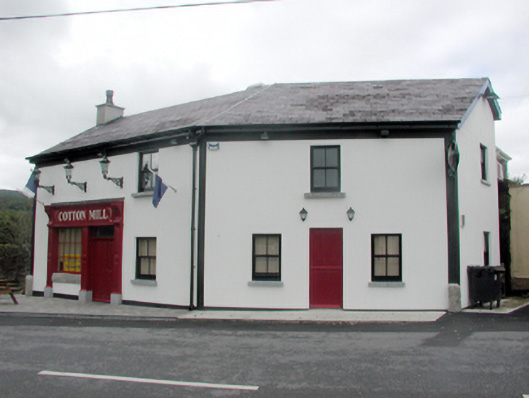
Detached five-bay two-storey house, c.1850, possibly originally two separate two-bay two-storey (south) and three-bay two-storey (north) houses on an L-shaped plan with chamfered elevation (comprising two bays to east and three bays to north-east), and five-bay two-storey return to west. Extensively renovated, 2002, with pubfront inserted to left ground floor. Pitched roofs (cranked to main block) with replacement slate, 2002, clay ridge tiles, rendered chimney stack, and replacement uPVC rainwater goods, 2002, on replacement timber and uPVC eaves, 2002. Painted replacement cement rendered walls, 2002, with rendered strips to ends, and band to eaves. Square-headed window openings with cut-stone sills, and replacement 2/2 timber sash windows, 2002. Square-headed door opening with replacement tongue-and-groove timber panelled door, 2002. Timber pubfront, 2002, to left ground floor with panelled pilasters, fixed-pane timber display window, timber panelled double doors with overlight, and fascia over having fluted consoles. Road fronted with concrete brick cobbled footpath to front, and granite wheelguard to corner.
An attractive building, possibly originally two separate houses, which retains an early footprint and arrangement to the openings, despite extensive reconstruction works at the turn of the century. Although much of the historic fabric and patina has been lost, some replacement fittings have been installed in keeping with the original integrity of the composition. However, the pubfront is of little inherent artistic design distinction, incorporating robust elements, and crude detailing. The building occupies a prominent site, and remains an important element of the street scene, the chamfered elevation accommodating the presentation of an elevation on to Main Street, with a further elevation fronting on to Bridge Street.
This does not grant access. Most recorded buildings are privately owned; view them only from public ground unless the owner allows entry.
Places near here
 worker's houseworker's house · 137 yd
 O'Neillhouse · 137 yd
 Portlaw Heritage CentreMuseum · 223 yd
 Portlaw WoodForest · 1596 yd
 CastleCastle, unclassified · 1.1 mi
 Beallough WoodForest · 1.3 mi
 Rockets Castle (in ruins)Castle, tower house · 1.3 mi
 Donnell's HillMountain / peak · 1.4 mi
 Grave YardGraveyard · 1.4 mi
 Enclosure in GuilcaghEnclosure · 1.5 mi
 Tower HillMountain / peak · 2.7 mi
 Waterford & Suir Valley RailwayHeritage attraction · 4.0 mi
Other information
Photo: National Inventory of Architectural Heritage · Website use allowed for educational or private purposes with source credit