What is recorded here
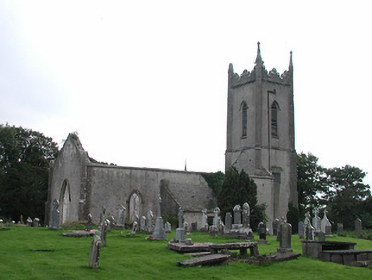
Ballymackey Church (site of) is a church in Cloonmore, County Tipperary, Ireland. The old rectangular graveyard holds a possible ivy-clad section of the west gable, measuring about 3.3 metres long, 2 metres high and 0.8 metres thick. South of this rise, the ruins of a Protestant church built around 1800 probably reuse material from the earlier building.
Situated on a rise in undulating tillage and pastureland. A roughly rectangular-shaped graveyard (TN021-020002) with no visible remains of a medieval church, except a possible portion of the W gable (L c. 3.3m; H c. 2m; wall T 0.8m), heavily ivy-clad, in the SW corner. South of the old graveyard and at a lower level, lie the ruins of a Protestant church, built c. 1800, probably incorporating the fabric of the earlier church. The oldest visible gravestone dates to 1780. According to the OS Letters the church was situated in the centre of the graveyard and the N end of the W gable was all that survived, incorporated in the E wall of a small school house (O'Flanagan 1930, vol. 3, 96-7). There are now no visible remains of the old school house which was marked on the 1st ed. OS 6-inch map.
The above description is derived from 'The Archaeological Inventory of County Tipperary. Vol. 1 - North Tipperary' compiled by Jean Farrelly and Caimin O'Brien (Dublin: Stationery Office, 2002). In certain instances the entries have been revised and updated in the light of recent research.
Date of upload/revision: 22 September 2008
The monument record does not grant public access. Check the route and ask the landowner before entering private land.
- What survives
- Recorded monument
Places near here
 Saint Michael's Church (Ballymackey)church/chapel · 29 yd
 Lisnamoe Houserectory/glebe/vicarage/curate's house · 189 yd
 Ballymackey CastleCastle · 449 yd
 Enclosure in ElmhillEnclosure · 1.2 mi
 Habitation site in ClashnevinHabitation site · 1.5 mi
 CastleCastle, tower house · 2.1 mi
 James Devaney MemorialMemorial · 2.3 mi
 Ballycapple WoodForest · 3.1 mi
 Kyleroe WoodWood · 3.5 mi
 Gibbet HillMountain / peak · 4.2 mi
 Old BarracksHeritage attraction · 4.5 mi
 Nenagh Heritage CentreMuseum · 4.7 mi