What is recorded here
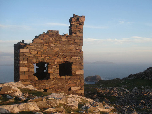
Indicated is a rectangular stone enclosure on a rocky Clare Island hill, built in 1804-6 around a signal tower to watch French ships during the Anglo-French Wars. The wall still stands about a metre high beside the tower and a limekiln, marking the narrow strip where fire, smoke and stone carried warnings across open water.
Located just off the summit of an exposed rocky hill, close to the sea cliffs on the extreme NW side of Clare Island. A rectangular walled enclosure (int. 26.6m N–S; 22.1m E–W) defined by a dilapidated mortared stone wall (Wth 0.6m; max. H 1.1m). It encloses, and is contemporary with, a stone-built signal tower (NIAH: Reg. No. 31308401), which was constructed in 1804-6 during the Anglo-French Wars. There is a limekiln (MA084-001003-) in the SW quadrant of the enclosure.
Descriptions of the enclosure (Catalogue entry no. 69, p. 137-138) and the signal tower (Catalogue entry no. 156, p. 181-182) are published in P. Gosling, C. Manning and J. Waddell (eds.), 2007 New Survey of Clare Island, Volume 5: Archaeology. RIA, Dublin.
Compiled by: Jane O'Shaughnessy
Date of upload: 13 July 2015
The monument record does not grant public access. Check the route and ask the landowner before entering private land.
- What survives
- Recorded monument
Places near here
 Clare Island Signal TowerRuins · 4 yd
 Shivel Head Signal Towersignal tower · 5 yd
 Enclosure in BunnamohaunEnclosure · 796 yd
 farm housefarm house · 1499 yd
 KnockmoreMountain / peak · 1.2 mi
 Clare IslandIsland · 2.0 mi
 ScalpatruceMountain / peak · 2.0 mi
 Granuaile's CastleCastle · 3.9 mi
 Caher IslandIsland · 5.8 mi
 Turloughbeg StrandBeach / strand · 6.5 mi
 Kildavnet CastleCastle, tower house · 6.9 mi
 Caisle án GhráinneHeritage attraction · 6.9 mi