What is recorded here
Indicated is a coastal promontory fort in County Kerry where a rock-cut ditch still traces the ward of Barrow Round Castle beneath a modern golf course. The castle faces inland because the sea and Creek of Fenit formed its true front, while the ditch cut the rocky headland from the main island. Men may have stood on that exposed edge, watching boats or defending a narrow entrance, before grass and fairways covered most of the warning line.
Promontory fort enclosing Barrow Round Castle (KE028-002001-) described by the SMR in 1989 as follows; 'The head land here has been developed into a golf course, so a great deal of landscaping has been undertaken. A definite ditch is visible running roughly N-S across the head, running out midway cross where it had been backfilled. This is c. 4' (1.2m) deep, U-shaped and c. 5m wide. It appears to have been rock cut in places. There is a low bank visible on the eastern side of the ditch c. 4m wide and c. 0.4m high' (SMR File). Ditch of promontory fort visible on air corps aerial photograph (V. 163/47) taken 10/05/1949 and on Hunting Surveys aerial photograph (7945/6) taken June 1962. Traces of promontory fort ditch visible c. 60m E of Barrow round castle on modern golf course.
Barrow Round Castle standing inside a possible promontory fort (KE028-028002-) reused as a bawn was described by Roe (1989, 407-17) as follows; 'The castle stands on the rocky south-western extremity of the townland, at the narrow entrance to an inlet of the sea which is bounded on its southern side by Fenit Island, near where part of the main channel is fully thirteen feet deep at low water of spring tides. This was the creek of Fenit, to which reference was frequently made in former centuries.
I am quite sure that this side of the castle was not protected by outer curtain-walling, which was almost certainly employed to cut off the building, and the rocky projection on which it stands, from the main-island land mass. The main doorway of Barrow Castle faces inland, its principal defence being against the sea across the Creek of Fenit. There is no evidence of curtain-walling, so its ward may well have extended to the ditch scored across the headland in a rough arc. This ditch is approximately 275 feet [84m] in length, the radial distance from the tower to its centre line varying from 197 feet [60m], at one extremity (roughly south), to 234 feet [71m] at the other (roughly north). It cannot have had a uniform width or depth, and appears to have been hacked out of solid rock in places: it probably varied between 12 feet [3.65m] and 15 feet [4.57m] in width, and was perhaps 6 feet [1.8m] in depth from the top of the earthwork thrown up on the outer bank only. The tussocky ground of the ward may well conceal foundations of some defensive works-near the castle a quite definite outline resembling three sides of a rectangle is discernible'.
See attached Google Earth orthoimage taken March 2022
Compiled by: Caimin O'Brien
Date of upload: 26 April 2022
The monument record does not grant public access. Check the route and ask the landowner before entering private land.
- What survives
- Recorded monument
Places near here
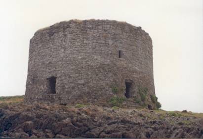 Barrow Round Castle (in ruins)Castle, tower house · 61 yd
 Fenit Castle (in ruins)Castle, tower house · 579 yd
 Chapel in Fenit WithinChapel · 720 yd
 Settlement desertedSettlement deserted, medieval · 856 yd
 Barrow Househouse · 1388 yd
 Enclosure in BarrowEnclosure · 1427 yd
 Tralee BayBay · 1.1 mi
 CloghnacroustaNamed rock · 1.4 mi
 Fenit BeachBeach / strand · 1.8 mi
 Samphire IslandIslet · 2.2 mi
 Samphire Island LittleIslet · 2.2 mi
 Saint BrendanMemorial · 2.3 mi