
Places near here
Photo credits
- Rossographer, Geograph · CC BY-SA 2.0
- Rossographer, Geograph · Creative Commons Attribution-ShareAlike 2.0
- Rossographer, Wikimedia Commons · CC BY-SA 2.0
- Albert Bridge, Geograph · CC BY-SA 2.0
- Albert Bridge, Wikimedia Commons · CC BY-SA 2.0
 Braniel HillMountain / peak · 486 yd
Explorer Tom Braniel Hill was designed by a mother-in-law who wanted to see everything but didn't want anyone seeing her, so she built herself a small hill with a view. It’s still judging your outfit from up there. Bring your own legend, I've run out.
 Church Ruins & Graveyard: Knock/dundela in KnockChurch Ruins & Graveyard: Knock/dundela · 1.2 mi
Explorer Tom Knock/Dundela in Knock has ruins and a graveyard with stories of Agnes Murphy and her kids from 1798. Medieval stuff is always dramatic. Tell your mates you found this one first, even if you didn’t.
 Knock Burial GroundCemetery · 1.3 mi
Explorer Tom Knock Burial Ground in County Down was where a priest lost a bet on who could yawn first, and the loser still hasn’t stopped. He’s been there since Tuesday. Ten minutes here and you'll have a yarn for the pub.
 Comber GreenwayWalking route · 1.3 mi
Explorer Tom Comber Greenway has a hidden treasure buried somewhere, which is definitely an empty biscuit tin from 1985. People dig for it every weekend with zero success or dignity. Pick a stone, any stone, and invent its biography.
 Lisnabreeny RathArchaeological place · 1.4 mi
Explorer Tom Lisnabreeny Rath sits up high like it’s judging your life choices from five hundred feet above sea level. It would list 'likes hiking' on its dating profile but honestly, the view is the real catch. Give it a pat on the way past, it's had a long life.
 Lisnabreeney WaterfallWaterfall · 1.5 mi
Explorer Tom Lisnabreeney Waterfall handles nosey neighbours by splashing them directly in the face until they remember their place and walk away quietly. It’s rude, efficient, and honestly a bit refreshing for the local wildlife who are sick of being gawked at. Go on a wet day, it suits the mood.
 Cregagh GlenWood · 1.5 mi
Explorer Tom Cregagh Glen is playing hide-and-seek with me, and honestly, I think a fox took charge last Tuesday and declared itself king of the steps. The glen is so steep it needs more footbridges than a proper city centre, which is ridiculous for a wee patch of trees. Tell your mates you found it first.
 Knock Methodist ChurchChurch · 1.7 mi
Explorer Tom Knock Methodist Church in Ballycloghan has a family tree that is basically just lies and gossip. Built in 1880, it’s been keeping score of who said what for decades. Hum something sad nearby, it adds atmosphere to your existential crisis.
 Orangefield Baptist ChurchChurch · 1.8 mi
Explorer Tom Ballyhackamore’s Orangefield Baptist Church is a modern Grade B2 gem from the sixties. It’s where a priest once lost a bet involving a goat and a very awkward handshake. A handy spot to stretch your legs and your imagination.
 The HollowWood · 2.1 mi
Explorer Tom The Hollow in County Down listens hard to the walls, convinced it can hear the ghosts arguing about whether the rain was heavy enough last Tuesday. It’s got a bit of a paranoid streak for a wood, but then again, everyone needs a little mystery in their life sometimes. Bring a camera and your most suspicious face.
 Moat ParkPark · 2.5 mi
Explorer Tom Moat Park was once ruled by a goat named Brenda who demanded tribute in form of lettuce heads and head scratches. She retired with dignity, but the fence still has her hoof marks, which is basically her signature on the whole operation. Bring a notebook and write the bit I made up.
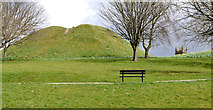 Dundonald MoatArchaeological place · 2.6 mi
Explorer Tom Dundonald Moat is probably rolling its eyes at the local sheep who keep using it as a personal playground, which is frankly disrespectful to its ancient dignity. It’s standing there looking slightly damp and very unimpressed by everyone’s attempts to take a serious selfie. Look serious, nod slowly, you're basically an expert now.
More archaeology and monuments in County Down · All of County Down

What do you know about this place?Tap to add a comment or ask a question