What is recorded here
From OpenStreetMap (© OpenStreetMap contributors) n9647915321
Places near here
Photo credits
- National Inventory of Architectural Heritage
- Derek Harper, Wikimedia Commons · CC BY-SA 2.0
- Jose Antonio Gutierrez D., Wikimedia Commons · CC BY-SA 4.0
- Marco Ober, Wikimedia Commons · CC BY-SA 4.0
- Phil Champion, Geograph · CC BY-SA 2.0
- Martin Southwood, Wikimedia Commons · CC BY-SA 2.0
- N Chadwick, Geograph · CC BY-SA 2.0
- Rod Allday, Geograph · CC BY-SA 2.0
- Jibi44, Wikimedia Commons · CC BY-SA 2.5
- Commander-pirx, Wikimedia Commons · CC BY-SA 4.0
- Michael Earnshaw, Geograph · CC BY-SA 2.0
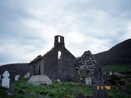 Séipéal na Cille [Killemlagh Catholic Chapel]Church/chapel · 765 yd
Explorer Tom Séipéal na Cille is playing possum without its roof, looking like it’s mid-sentence. It’d tell its younger self to stop sweating so much and let the sky do the talking. Have a wander and a wonder.
 Chaytor's StablesRuins · 1.7 mi
 Wedge tomb in An Com (bar. Uíbh Ráthach)Wedge tomb · 2.3 mi
Explorer Tom Wedge tomb in An Com thinks one massive roof stone makes it look cool and mysterious. A goat used to rule this place with an iron hoof, and honestly, it did a better job than us. Have a sandwich here and call it a heritage lunch.
 Kerry CliffsHeritage attraction · 2.4 mi
 Skellig Experience CentreMuseum · 2.8 mi
 Horse IslandIslet · 3.3 mi
 Telegraph Field Valentia IslandMemorial · 3.5 mi
 Ballinskelligs Castle (in Ruins)Castle, tower house · 3.7 mi
 Ballinskelligs PrioryVisitor information · 3.8 mi
 ValentiaIsland · 3.9 mi
 Fermoyle Castle (in Ruins)Castle, tower house · 3.9 mi
Explorer Tom Fermoyle Castle in Formaoil is still sulking about losing its walls to the elements. It wants a rematch with Ross Castle but forgot it only has one side left. Best enjoyed with a bag of chips and no plans.
 Bolus PointHeadland · 4.2 mi
More archaeology and monuments in County Kerry · All of County Kerry

What do you know about this place?Tap to add a comment or ask a question