What is recorded here
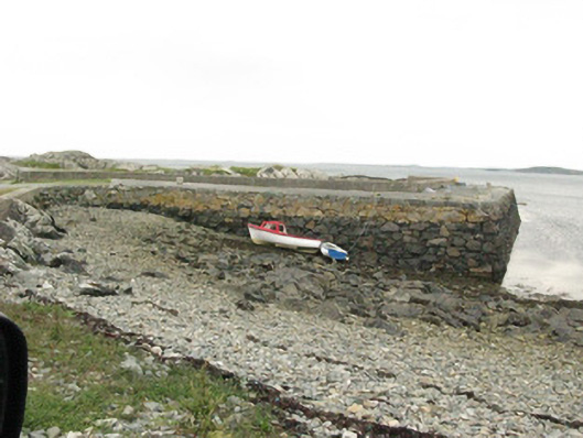
Quay or wharf in Drimmeen bends into an S and makes two harbours, the sort of solution you get when both ends of the village insist the boats should park near them. You’d swear the bend marks where the chairman finally lost his temper.
Freestanding S-plan quay, built c.1867, with bowed terminus, and creating two artificial harbours. Recent addition to north-west blocks entrance to western harbour, and recent retaining wall to south along approach road. Battered rubble stone walls of squared limestone blocks with limestone steps to water level to north-east elevation. Recent concrete parapet wall to interior elevations of western harbour, limestone and concrete coping with cylindrical granite mooring posts and iron mooring rings. Rubble stone and concrete retaining wall to approach road with both concrete steps and protruding stone steps to north elevation. Modern repairs to parts of quay from storm in 1991.
It is evident that considerable effort went into the construction of this pier which is attested to by the size of the large cut limestone blocks of which it is constructed. This quay performs the important role of protecting boats for the local community which grouped together to raise funds for reconstruction of the pier after a storm in 1991 which almost destroyed the quay walls. It retains many interesting features such as the granite mooring posts, iron mooring rings and stone steps, all of which contribute to the functionality and aesthetic quality of the quay.
From the Buildings of Ireland (National Inventory of Architectural Heritage) record 30403505
This does not grant access. Most recorded buildings are privately owned; view them only from public ground unless the owner allows entry.
Places near here
 Errislannan ManorHunting/fishing lodge · 1558 yd
 Clifden Coastguard StationCoastguard station · 1.1 mi
 Sky RoadViewpoint · 1.2 mi
 Clifden CastleCastle · 1.4 mi
 Boolard IslandIslet · 2.0 mi
 Mannin BayBay · 2.2 mi
 Graveyard2.3 mi
 Letterdeen Standing StoneArchaeological place · 2.5 mi
 Station House MuseumMuseum · 2.9 mi
 The StrandBeach / strand · 4.4 mi
 Omey IslandIsland · 4.5 mi
 Doon HillMountain / peak · 4.9 mi
Pictures: National Inventory of Architectural Heritage; Ian Capper, Geograph · CC BY-SA 2.0; Drow69, Wikimedia Commons · CC BY-SA 3.0; Keith Salvesen, Geograph · CC BY-SA 2.0; United Kingdom Hydrographic Office, Wikimedia Commons · Public domain; Oliver Dixon, Geograph · Creative Commons Attribution-ShareAlike 2.0; Newbert12, Wikimedia Commons · CC BY-SA 4.0; Markbriggs, Wikimedia Commons · CC BY-SA 3.0; Patrice78500, Wikimedia Commons · CC BY-SA 3.0
More historic places in County Galway · All of County Galway
What do you know about this place?