Overview
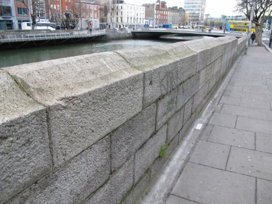
quay/wharf — Burgh Quay is recorded as quay/wharf in Dublin. Dressed ashlar granite quay wall, erected c.1820, with bell-profile coping. Cast-iron ladders and remains of timber and cast-iron mooring fixtures.
Why it was built
The saved account records: Dressed ashlar granite quay wall, erected c.1820, with bell-profile coping.
People and work
The saved account records: Cast-iron ladders and remains of timber and cast-iron mooring fixtures.
How it changed
The saved account records: Culverted River Stein flows into River Liffey to north elevation of wall.
What survives
The official record fixes the place and calls it quay/wharf. It does not provide a full list of finds or a current condition report, so visible and buried remains are not guessed.
Why it mattered
quay/wharf — Burgh Quay matters for the exact reasons given in its official assessment, rather than merely because it is an old structure. The source records: The area of Burgh Quay was slob land in the early years of the eighteenth century, until William Mercer received a grant to infill and create what became George’s Quay and Burgh Quay. The Wide Street Commission created a continuous street along the south side of the river in 1820 by removing intervening houses and constructing the cut stone quay walls. This quay wall serves an important practical function in supporting the raised river bank, and is a notable reminder of the civil engineering heritage of the city. Its execution in ashlar granite attests to the high level of skill and artisanship employed in its… This explains what the place adds to local life, the street or the surviving built history.
History checked 15 August 2026 against the named sources below.
Places near here
- post box — Burgh Quaybuildingunder 0.1 miles
- Jaffa Deli/ Speedy India Ireland/ Visa Care Global — Burgh Quaybuildingunder 0.1 miles
- Birmingham Cameras — Burgh Quaybuildingunder 0.1 miles
- English Language Tutorial Academy — Burgh Quaybuildingunder 0.1 miles
- house — Burgh Quaybuildingunder 0.1 miles
- Corn Exchange — Burgh Quaybuildingunder 0.1 miles
- Padraig Sheahan Memorialmemorialunder 0.1 miles
- Sheahan Memorial — Burgh Quaybuildingunder 0.1 miles
- Irish Naturalisation and Immigration Board — Burgh Quaybuildingunder 0.1 miles
- quay/wharf — Eden Quaybuildingunder 0.1 miles
- Dublin Gaslight Company 1825memorialunder 0.1 miles
- office — Hawkins Streetbuildingunder 0.1 miles
Add the human story, a picture, a first-hand message or a missing place.
Earn 5 points after the picture is checked and accepted.
Add a pictureAdd its storyTalk or ask a questionAdd a new placeThis official record and map point do not grant access. Most recorded buildings are privately owned; view them only from public ground unless the owner allows entry.
Conversation about this place
Questions and messages sit beneath the source record. They are checked before appearing.
No questions or messages yet.
Ask a question or join the conversation