What is recorded here
From the National Monuments Service (Archaeological Survey of Ireland) record CW016-040002
Places near here
Photo credits
- National Inventory of Architectural Heritage
- A.-K. D., Wikimedia Commons · CC0
- Maker not stated on source page, en.wikipedia.org
- Maker not stated on source page, www.dreamstime.com
- Maker not stated on source page, commons.wikimedia.org
- liam murphy, Geograph · Creative Commons Attribution-ShareAlike 2.0
- A.-K. D., Wikimedia Commons · CC BY-SA 4.0
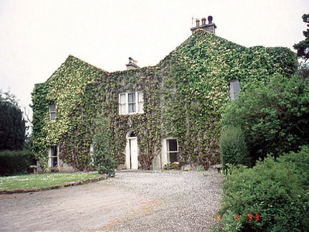 EastwoodHouse · 898 yd
Explorer Tom Eastwood House has a U-shaped plan and an open-well staircase, which sounds great until you have to climb it in socks.…
 Saint Mary's Church (Dunleckny)School · 1118 yd
Explorer Tom Saint Mary's Church (Dunleckny) in Moneybeg is a former school with a teacher’s block that’s now a house, which feels…
 Lodge MillsMill (water) · 1139 yd
Explorer Tom Lodge Mills in Moneybeg has seven storeys and looks like a warehouse that lost its way and ended up as a mill. A priest…
 Lock Keeper's House and Lodge MillsVisitor information · 1167 yd
Explorer Tom Lock Keeper's House and Lodge Mills in County Carlow is where the rabbits hold their weekly strategy meetings to take…
 lock1171 yd
Explorer Tom Lock in Moneybeg has replacement gates but still feels like it’s running out of time. A cow once tried to buy it with a…
 bridge1176 yd
Explorer Tom Bridge in Moneybeg is just the remains of a lifting bridge from 1870, which means it used to go up and down but now…
 Church (In Ruins)Ecclesiastical enclosure · 1230 yd
Explorer Tom Church (In Ruins) in Fenniscourt is pear-shaped, which is weird for a church unless they were really into fruit puns…
 Graveyard in FenniscourtGraveyard · 1230 yd
Explorer Tom Graveyard in Fenniscourt got chewed up by gravel trucks, so its dating profile just says 'looking for stability'. The…
 HollodenHouse · 1282 yd
Explorer Tom Holloden in Clorusk Lower is derelict but keeping its dignity with those oriental motifs on the stables. The wind keeps…
 Graveyard at WellsGraveyard · 1460 yd
Explorer Tom Graveyard at Wells would cope on a reality show by simply refusing to change its wardrobe. It’s too dignified to worry…
 Grave YardGraveyard · 1465 yd
Explorer Tom Graveyard in Wells is irregularly shaped because nobody could decide if they wanted a square or an oval, so they just…
 The Columban WayVisitor information · 1533 yd
Explorer Tom The Columban Way had a matchmaker who worked there for decades, pairing up lonely walkers with particularly handsome…
More historic places in County Carlow · All of County Carlow

What do you know about this place?Tap to add a comment or ask a question