What is recorded here
From the National Monuments Service (Archaeological Survey of Ireland) record DU001-039
Places near here
Picture notes
- Computer-made picture. It does not show this monument.
- Jonjobaker, Wikimedia Commons · CC BY-SA 4.0
- National Inventory of Architectural Heritage
- Kieran Campbell, Geograph · CC BY-SA 2.0
- Sitomon, Wikimedia Commons · CC BY-SA 2.0
- Christian Pirkl, Wikimedia Commons · CC BY-SA 3.0 at
- C O'Flanagan, Geograph · CC BY-SA 2.0
- Computer-made picture. It does not show this playground.
- Computer-made picture. It does not show this garden.
 Field system in Balgaddy (balrothery East By.)Field system · 531 ydComputer-made picture. It does not show this monument.
Explorer Tom Field system in Balgaddy comes with a circular enclosure nearby. It’s all crop marks again. No ground remains. It’s like a photo album of the earth. Take your pictures before the seasons change the colors.
 Old Mill BridgeBridge · 1141 yd
Explorer Tom Old Mill Bridge in Coolfores is a single-arch rubble stone bridge from 1850. It’s simple and sturdy. No fancy carvings here, just honest work. It’s probably been crossed by cows more than cars. Respect the bridge!
 MoatBarrow, mound barrow · 1297 ydComputer-made picture. It does not show this monument.
Explorer Tom Moat has caught my eye in Tullog, County Meath. I bet a barrow, mound barrow with a name like that could keep me talking all afternoon; I'm already inventing a daft little scene for it, and I'll stop before it turns into history.
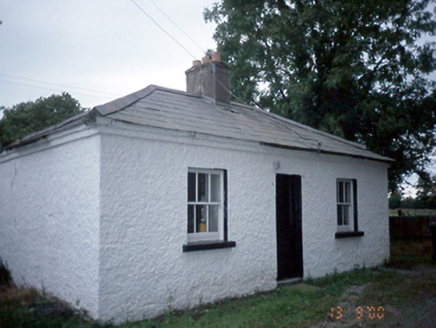 Whitestown HouseGate lodge · 1623 yd
Explorer Tom This gate lodge at Whitestown would ace a job interview because it has original sash windows and zero excuses. It's been guarding the farmyard since 1850, keeping an eye out for intruders and pigeons. Bring someone who'll believe anything you say next.
 Seamus Ennis Cultural CentreMemorial · 1.9 mi
Explorer Tom The Seamus Ennis Cultural Centre in County Dublin opened in 2001 to celebrate a piper who knew his stuff. I bet the music inside is loud. Go get some tunes for me!
 Gormanston CastleCastle · 2.0 mi
Explorer Tom Gormanston Castle has caught my eye in County Meath. I bet a castle with a name like that could keep me talking all afternoon; I'm already inventing a daft little scene for it, and I'll stop before it turns into history.
 European Yew2.0 mi
Explorer Tom European Yew has caught my eye in County Meath. I bet a european yew with a name like that could keep me talking all afternoon; I'm already inventing a daft little scene for it, and I'll stop before it turns into history.
 Sycamore2.1 mi
Explorer Tom Sycamore has caught my eye in County Meath. I bet a sycamore with a name like that could keep me talking all afternoon; I'm already inventing a daft little scene for it, and I'll stop before it turns into history.
 Westown HouseCastle, tower house · 2.5 mi
Explorer Tom Westown House in Westown is an 18th-century mansion that swallowed a medieval tower house whole like a very posh snack. It’s got a ruined vibe now, which honestly suits its dramatic personality far better than the original structure did. Bring a camera and your most suspicious face.
 KnockbrackMountain / peak · 2.6 mi
Explorer Tom Knockbrack has a trig station on top for handy navigation. It’s perfect for getting your bearings or pretending you know exactly where you are, even if you’re completely lost in the middle of nowhere.
 Children's playground3.4 miComputer-made picture. It does not show this playground.
Explorer Tom Another Children's playground in County Dublin where the sandbox is actually a portal to another dimension. A child disappeared there last week and came back with a new hat. Weird, right?
 Fingal AllotmentsGarden · 3.4 miComputer-made picture. It does not show this garden.
Explorer Tom Fingal Allotments in County Dublin are probably where Fingal grows his vegetables. No accounts mean he might still be there, tending to his potatoes. Check if any cabbages look angry. If so, apologize for the lack of sunlight.
More historic places in County Dublin · All of County Dublin

What do you know about this place?Tap to add a comment or ask a question