What is recorded here
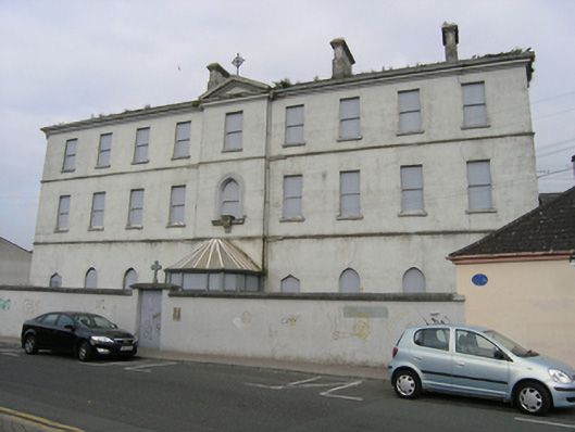
Nine-bay three-storey over basement convent, built c. 1830 advanced and pedimented middle entrance bay surmounted by a cross at apex and with glass porch enclosing entrance door, incorporating the truncated remains of circular tower, built c. 1560, heightened 1872, now disused. The garden front is comprises a two-storey gabled entrance with bell-cote at apex, approached by a flight of steps, flanked by advanced gabled wings - a chapel and classroom (former chapel) wing, the south advanced gabled wing extended with twentieth-century two-storey flat-roof seven-bay bow. Slate roof with clay ridge tiles, hipped to main block, conical roof to tower, tall rendered stacks, cast-iron rainwater goods. Ruled and lined ashlar painted render, plat bands divide the storeys below a heavy moulded cornice, large variety of openings - square-headed, triangular, lancet and round-headed, moulded jambs to the lancet window on the first floor entrance bay with a statue bracket at sill level, raised architrave around the garden front door with side lights within a round arch with bracketed niche in the tympanum, round-headed graduated triplet in the storey above, flanked by narrow square-headed lights above round-headed examples below. Openings blocked, some with sash windows visible. Set behind a high boundary wall and shallow garden flanking the street and formal garden to the rear with a pair of statue plinths, orangery to north side, informal rockery/grotto to the east end and footbridge over the Triogue River. Decorative ironwork to gates at front and rear.
A building with a complex architectural development. Built as a convent in 1830 it incorporates elements of the 'Stonehouse' or 'Anthony Rogers' House' and a tower, indicated on a 1565 map of the Fort of Maryborough and surrounding settlement. It has evolved since then, marking important changes in the town. In the seventeenth and eighteenth centuries the building was used for a variety of purposes - a constable's house, a gaol, an infirmary - in 1756 under the direction of Dr. Michael Jacob - and finally a convent for the Presentation Sisters from 1824. The tower was examined by local historian Michael Deigan in 1991, he described the basement as having walls 1.37 metres thick with a diameter of 4.1 metres.
This does not grant access. Most recorded buildings are privately owned; view them only from public ground unless the owner allows entry.
Places near here
 ConventCastle, tower house · 14 yd
 Sacred Heart Primary Schoolschool · 56 yd
 Town defences in MaryboroughTown defences · 84 yd
 Fort of Maryboroughfortification · 105 yd
 Old Barrack, Mill LandCastle, unclassified · 108 yd
 Ridge Grave YardGraveyard · 193 yd
 Burial Ridge of MaryboroughMemorial · 217 yd
 Portlaoise CourthouseMemorial · 271 yd
 Rock of DunamaseCastle · 3.6 mi
 Rock of Dunamase InformationVisitor information · 3.7 mi
 Rock of CashelMountain / peak · 3.8 mi
 Giant SequoiaGiant Sequoia · 6.4 mi
Other information
Photo: National Inventory of Architectural Heritage · Website use allowed for educational or private purposes with source credit