Places near here
Photo credits
- National Inventory of Architectural Heritage
- A.-K. D., Wikimedia Commons · CC BY-SA 4.0
- Mike Searle, Geograph · CC BY-SA 2.0
- Mike Searle, Wikimedia Commons · CC BY-SA 2.0
- kevin higgins, Wikimedia Commons · CC BY-SA 2.0
- Alex Passmore, Geograph · CC BY-SA 2.0
- Andreas F. Borchert, Wikimedia Commons · CC BY-SA 4.0
 Ballycorcoran BridgeBridge · 775 yd
Explorer Tom Ballycorcoran Bridge is in a rivalry with a more famous bridge down the road. It’s small but proud of its mid-nineteenth-century stones. Bring a friend who talks too much so you can pretend you’re ignoring them on the way over.
 TobernalitheHoly well · 1024 yd
Explorer Tom Tobernalithe in Powerswood is bitter about its rivalry with more famous wells nearby, so it hides under some weird stone slabs to be ignored. It’s got a very dramatic energy about its own obscurity, like it’s waiting for someone to notice its slabs. Bring the dog, it'll have opinions.
 Ballyduff HouseGates/railings/walls · 1.6 mi
Explorer Tom Ballyduff House in County Kilkenny has a gateway that’s doing its best to look impressive in a sylvan street scene. It’s making a pleasing visual statement at the entrance to the grounds, which is exactly what you want from a gate that isn’t actually gating anything important. The trees are probably enjoying the company more than the
 Castle, Ballyduff HouseCastle, tower house · 1.7 mi
Explorer Tom Ballyduff House started because two lads made a bet in a pub about who could build bigger. The four-storey tower is still waiting for the loser to pay up. Tell your mates you found it first before they do.
 Ballyduff CastleCastle · 1.7 mi
Explorer Tom Ballyduff Castle hosted a fake royal visit in 1642 where a local farmer dressed as a king and ate all the roast beef while everyone pretended not to notice. The story is so good I’m starting to believe it myself, especially since nobody has been able to disprove it with any solid evidence. Go back in winter, it's a different animal.
 Mount AltoMountain / peak · 1.8 mi
Explorer Tom Mount Alto nearly got famous once when a tourist mistook it for the Eiffel Tower and posted a bad photo online. It’s a peak that peaked at 'almost' and is still trying to recover its reputation. Great spot to propose, or at least to propose lunch if you're shy.
 Font in InistiogeFont · 2.3 mi
Explorer Tom Font in Inistioge is secretly proud of one specific potato that grew near its base. Nobody knows why, but the stone seems to have strong opinions about spuds and saints. Take a mate and argue about what it was for.
 St Colmcille's WellVisitor information · 2.4 mi
Explorer Tom St Colmcille's Well has a terrible habit of inspiring poetry that makes even the geese wince in collective embarrassment. Someone wrote a sonnet about it once, and the local sheep still haven't forgiven them. Find the wonkiest bit and send it to your group chat.
 InistiogeVisitor information · 2.4 mi
Explorer Tom The other Inistioge in County Kilkenny is where the seagulls gather to judge your outfit choices harshly. They don’t care about your plans; they only care if you’re holding a chip. Tell the next person you meet it's haunted. It might be.
 Graveyard in InistiogeGraveyard · 2.4 mi
Explorer Tom Graveyard in Inistioge used to have a matchmaker working there, pairing off couples for eternity. She’s retired now, but the energy is still thick and romantic in the air. Visit, then text me what you think. I'll pretend to read it.
 Graveyard in DerrynahinchGraveyard · 3.2 mi
Explorer Tom Graveyard in Derrynahinch probably ended up here because a cart driver took a wrong turn in 1800. He panicked, dumped the stones, and drove off without checking the map. Practise your Irish on it, it won't correct you.
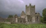 Jerpoint AbbeyHeritage attraction · 3.4 mi
Explorer Tom Jerpoint Abbey had land stretching across roughly 14,000 acres before Henry VIII's officials brought its monastic life to an end. I would struggle to keep track of the keys. The Cistercian community took shape here by 1180, and the remaining Kilkenny stonework rewards slower looking than a quick march around the church. Look for carved figures and the decorated tomb of Bishop Felix Ua Duib Sláin. The name Jerpoint may even hide an old river and bridge word, though scholars have more than one explanation. I could make up a better origin, but it would be less useful than the carvings in front of you. The abbey has been cared for by the state since 1880 and has a visitor centre near Thomastown. Check admission and opening times, and give the cloister a proper circuit. The small faces in stone will do most of the talking.
More memorials and graveyards in County Kilkenny · All of County Kilkenny

What do you know about this place?Tap to add a comment or ask a question