
Places near here
Photo credits
- Humphrey Bolton, Wikimedia Commons · CC BY-SA 2.0
- Peter McDermott, Wikimedia Commons · CC BY-SA 2.0
- John H Darch, Wikimedia Commons · CC BY-SA 2.0
- Stephen Craven, Wikimedia Commons · CC BY-SA 2.0
- Chris Heaton, Wikimedia Commons · CC BY-SA 2.0
- Kevin Waterhouse, Wikimedia Commons · CC BY-SA 2.0
- habiloid, Wikimedia Commons · CC BY-SA 2.0
- N Chadwick, Wikimedia Commons · CC BY-SA 2.0
- Maximilian Dörrbecker ( Chumwa ), Wikimedia Commons · CC BY-SA 3.0
- Alexander P Kapp, Wikimedia Commons · CC BY-SA 2.0
 Waterfall, OtterburnWaterfall · 518 yd
 Robcross HillMountain / peak · 1172 yd
 Otterburn BridgeListed building · 1215 yd
 Otterburn HallListed building · 1455 yd
 Wenningber HillMountain / peak · 1540 yd
 Boundary stone?Monument or public art · 1.0 mi
 Boundary Stone, Scosthrop / AirtonMonument or public art · 1.2 mi
 Nor Croft SpringSpring · 1.4 mi
 Hanlith WoodWood · 1.7 mi
 Pits Hill PlantationWood · 1.7 mi
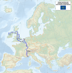 European walking route E2 west, UK, Yorkshire and the Humber, West RouteWalking route · 1.8 mi
 Long Preston War MemorialMemorial · 3.0 mi
More mountains and hills in North Yorkshire · All of North Yorkshire

What do you know about this place?Tap to add a comment or ask a question