Places near here
Photo credits
- Humphrey Bolton, Geograph · CC BY-SA 2.0
- Jtonra, Wikimedia Commons · CC BY-SA 4.0
- Drow69, Wikimedia Commons · CC BY-SA 4.0
- JuneGloom07, Wikimedia Commons · CC BY-SA 4.0
- National Inventory of Architectural Heritage
- Mac McCarron, Geograph · CC BY-SA 2.0
- Bob Jones, Geograph · CC BY-SA 2.0
- Adrian King, Geograph · CC BY-SA 2.0
- Joseph Mischyshyn, Geograph · CC BY-SA 2.0
- C Michael Hogan, Geograph · CC BY-SA 2.0
 Burren National ParkVisitor information · 1663 yd
Explorer Tom Burren National Park in County Clare looks at Dublin tourists like they’re flies that wandered into a very fancy kitchen. It’s all about the rocks and the weird flowers, not your fancy city shoes. Bring wellies and low expectations, leave delighted.
 Dermot and Granias BedWedge tomb · 1.2 mi
Explorer Tom The bishop refused to visit Dermot and Granias Bed because he thought it was too much like a bed and not enough like a tomb. It’s a well-preserved wedge tomb in the middle of a cashel, looking very comfortable with its intact capstone. Pop by and tell it it's looking well.
 CahercommaunFairy fort / stone ringfort · 1.2 mi
Explorer Tom Cahercommaun is a triple-walled fortress that looks like it survived a zombie attack and then complained about the mess. It’s sitting on a ravine edge, ready to drop you if you look at it wrong. Best enjoyed with a bag of chips and no plans.
.jpg/250px-Father_Ted's_House_(2016).jpg "Photo: JuneGloom07, Wikimedia Commons · CC BY-SA 4.0") Father Ted's HouseHeritage attraction · 1.5 mi
Father Ted's HouseHeritage attraction · 1.5 miExplorer Tom Father Ted's House refuses to collapse because it thinks if it falls, the comedy dies and nobody will buy the merch anymore. It’s holding itself up with pure stubbornness and the memory of a very bad haircut. Best enjoyed with a bag of chips and no plans.
Glenquin HouseFarm house · 1.5 miExplorer Tom Glenquin House in Poulnalour was used for Father Ted, so it’s basically a shrine to bad puns. It would post a selfie on social media with the caption 'Living my best parochial life.' Stand there long enough and someone will ask if you're lost or just weird.
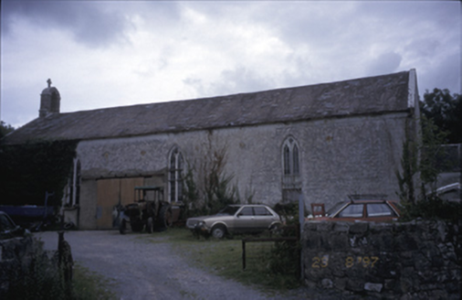 Saint Joseph's Catholic ChurchChurch/chapel · 2.0 mi
Explorer Tom Saint Joseph's Catholic Church in Killinaboy is now an outbuilding, which means its New Year’s resolution was to stop being holy and start storing things. It’s got a square-headed opening from 1975 that looks like a yawn. Spot the oldest stone and give it a name like 'Grumpy'.
 Castle in ruinsCastle, tower house · 2.1 mi
Explorer Tom Castle in ruins near Carran Turlough is secretly proud of the potato growing next to its foundation because the castle is doing worse. It controls a routeway but mostly just controls your sense of direction. Pretend it's yours and plan the housewarming.
 Inchiquin Castle (in ruins)Castle, tower house · 3.1 mi
Explorer Tom Inchiquin Castle is perched on a rocky bluff, looking down its nose at the lough below. Built by a king, ruined by time, and still acting like it's the center of the universe. Wave at the cows, they're the real locals.
 Inchiquin IslandIslet · 3.2 mi
Explorer Tom Inchiquin Island was built on a bargain where someone traded a secret recipe for a chunk of land in Lough Inchiquin. Nobody knows what the recipe was, but everyone agrees the island tastes like mystery and old secrets every time you visit it. Ideal spot for a dramatic phone call.
 Rock IslandIsland · 3.2 mi
Explorer Tom Rock Island is having a bit of a mood today, refusing to be the best man at its own wedding. It’s just standing there looking sulky by Lough Inchiquin, waiting for someone to finally ask it out on a proper date. Pop by and tell it it's looking well.
 Poulnabrone - Burren GeositeVisitor information · 4.8 mi
Explorer Tom Poulnabrone is famous for being saved by a hero nobody remembers who just happened to be passing by with a really strong umbrella and good luck on his side during a particularly bad storm. He didn't even write a book about it or get a statue erected, he just walked away and went home for tea, leaving the dolmen to take all the credit for its survival over the centuries that followed after
 The Portal TombVisitor information · 4.8 mi
Explorer Tom The Monastery of St. Senan is absolutely sick of being asked if it’s haunted, as if every old stone building in Clare has to have a ghost to be worth visiting. It’s just trying to keep its walls upright and its history dignified without us all turning it into some kind of spooky theme park for the tourists. Stick around for the light
More caves in County Clare · All of County Clare

What do you know about this place?Tap to add a comment or ask a question