Places near here
Photo credits
- Colin Park, Geograph · CC BY-SA 2.0
- Keith Cunneen, Geograph · CC BY-SA 2.0
- Peter Craine, Wikimedia Commons · CC BY-SA 2.0
- National Inventory of Architectural Heritage
- Andreas F. Borchert, Wikimedia Commons · CC BY-SA 4.0
- Michael Westley, Wikimedia Commons · CC BY-SA 2.0
- Ben Brooksbank, Geograph · CC BY-SA 2.0
- Ben Brooksbank, Wikimedia Commons · CC BY-SA 2.0
- Peter Clarke, Wikimedia Commons · CC BY-SA 3.0
- John Tann from Sydney, Australia, Wikimedia Commons · CC BY 2.0
- Nigel Cox, Geograph · CC BY-SA 2.0
 Derrynafulla swMountain / peak · 1.1 mi
 Killane Mountain South-West TopMountain / peak · 1.8 mi
 Glengarriff WoodsWood · 2.2 mi
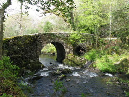 Glengarriff Nature ReserveBridge · 2.6 mi
Explorer Tom Glengarriff Nature Reserve bridge is picturesque and full of local craftsmanship, featuring a second smaller arch that acts as an overflow during floods. It’s part of the demesne group, so it’s basically the nature reserve's flood-control superhero. Bring your camera for the shot!
 Sacred Heart Roman Catholic ChurchChurch/chapel · 3.1 mi
Explorer Tom Sacred Heart Roman Catholic Church in Cappyaughna, County Cork is a Gothic Revival showpiece from 1902 with stained glass that’ll blind you. The bellcote is carved so nicely you just have to stare at it.
 Italian GardenGarden · 3.5 mi
 GarinishIsland · 3.6 mi
 IlnacullinIsland · 3.6 mi
Explorer Tom Ilnacullin Island has a hidden message in its stones if you squint hard enough at the Caha Mountains. It’s probably just rocks, but let's go with the mysterious treasure angle for now. Look for the ghost, then pretend you didn't.
 Garnish IslandIsland · 3.6 mi
 Tasmanian bluegum3.7 mi
Explorer Tom Another Tasmanian bluegum in County Cork was nearly sold for a horse last Tuesday, but the buyer changed his mind. Tell the next person you meet it's haunted. It might be, or just damp.
 Gleninchaquin WaterfallWaterfall · 3.8 mi
 Glengarriff BayBay · 4.4 mi
More archaeology and monuments in County Cork · All of County Cork

What do you know about this place?Tap to add a comment or ask a question